First settlements: Cresswell township, fall of 1869, by Henry Endicott, Sr. and Larkin Moyer; Dexter township, January 6th, 1870, James Cloud and family; Silverdale township, December, 1869, George B. Green and Russell Damewood; Tisdale township, fall of 1870, John Phillips. - First churches: Arkansas City, 1873, Liberal Church; Winfield City, 1871, Methodist. - First school houses: Cresswell township, Arkansas City, 1871, by district No. 2; Dexter township, 1872, district No. 5; Silverdale township, 1872, district No. 28; Tisdale township, 1872, district No. 42; Winfield township, 1872, district No. 1. - First business established: Cresswell township, general country store, by Norton Bros.; Dexter township, general country store, Tyler & Evans; Silverdale township, general country store, S. C. Wintin; Tisdale township, J. A. McGuire. - First marriages: Cresswell township, John Brown and Eva Woolsey, October 30th, 1870, Silverdale township, Elic C Cranston and Esther Bennett, November 7th, 1870; Tisdale township, Perry Chance and Tillie Moore, July 30th, 1872; Winfield township, A. A. Jackson and G. A. Kelsey, September 4th, 1870. - First Births: Cresswell township, Creswell Grote, Dexter township, S. F. Graham; Silverdale township, George Fetterman; Tisdale township, Willie C. Bryant. - First post offices: Cresswell township, Arkansas City, G. H. Norton, postmaster; Dexter township, Dexter, September, 1870, J. B. Todd, postmaster; Silverdale township, 1872, John Kennedy, postmaster; Tisdale township, at Tisdale, 1871, John A McGuire, postmaster.
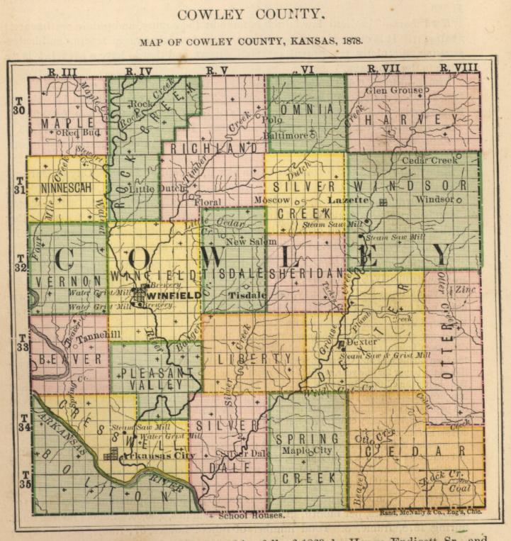
Cowley county was organized in 1870.
NAVIGATION OF THE UPPER ARKANSAS RIVER.
The question of utilizing that vast, though ever-changing current of water, known as the Upper Arkansas river, flowing through our State from west to southeast, and making it the highway to a southern market, has been a living subject with the enterprising agricultural people of Cowley, Sumner, Sedgwick, and those counties lying along and contiguous thereto, ever since the first settlement of that fertile valley in 1870. Owing to their remote distance from a railroad or a market, and the consequent cost of transporting the vast surplus of wheat raised in Cowley and sumner, has this matter been of vital interest to the people living within their borders. The subject has been discussed in the field and in the grange; has been the slogan of the country politician and the shibboleth of the farmers. It has been resolved upon by conventions, petitioned for by representatives and memorialized by our State Legislature until Congress has taken the matter under consideration, and appointed a commission of competent engineers to personally visit, examine and report on the feasibility of opening up the stream for navigation, from some point near the terminus of the Wichita branch of the Santa Fe Railroad to Little Rock, Arkansas.
In view of these facts, a brief account of the local and individual efforts to solve the problem will doubtless be of interest. During the fall of 1875, A. W. Berkley and A. C. Winton, of Cowley county, built a small flat-boat at Arkansas City, loaded it with flour, and started down the river, bound for Little Rock. While they may not have had the "unexplored wilderness" that lay between De Soto and the dream of his ambition, or the dangers that beset Coronado in his march of disappointment through undiscovered Kansas, to encounter, yet four hundred and fifty miles of an unknown river, guarded by a semi-barbarous people who have no particular good feeling towards a frontiersman, lay between them and civilization, presented anything but a cheerful outlook for this pioneer voyage. The trip was made, however, without adventure, and in a reasonable length of time. The produce disposed of, the navigators returned overland to Arkansas City, and reported a fair depth of water and a lively current from the State line to Fort Gibson.
On the strength of this report, a joint stock company was immediately organized, and an agent appointed to proceed at once to the Ohio river and purchase a suitable steamer to ply between the points name. A light draft wharf packet was procured, and a point known as Webbers' Falls, power to stem the current, so she was taken back to Little Rock, and Fort Gibson, reached on her upward trip. Here it was found that her engines were of insufficient power to stem the current, so she was taken back to Little Rock, and there sold at a loss to her owners of twenty-five hundred dollars.
This failure temporarily dampened the ardor of even the enthusiastic commercial path-finders, and nothing further was attempted until the summer of 1878, when Messrs. W. H. Speer and Amos Walton, two leading public spirited citizens of the county, equipped a "ferry flat" with a 10 horse-power threshing machine engine, and by several trips up and down the river for a distance of 60 miles from Arkansas City, demonstrated beyond a doubt that a steamer could be successfully propelled on the Arkansas river at any season of the year. The flat was fifty feet long, sixty feet wide, and drew ten inches of water, this novel little craft visited Grouse creek, the Walnut river, Salt City, the Kaw Indian Agency, Oxford and other points along the river, and attracted crowds of people wherever it went. At Oxford a public reception was tendered its officers and crew. These experimental trips were all made while the river was at its lowest stage, and prior to the annual "June rise."
Soon after this, and while the "ferry flat" was still prominently before the public, Mr. I. H. Bonsall an experienced engineer and prominent citizen of Arkansas City, corresponded with the business men of Little Rock, and induced them to send a boat on a trial trip to the upper country.
NEED PICTURE
THE "AUNT SALLY."
(From a photograph by I. H. Bonsall.)
The little steamer "Aunt Sally," (see engraving), a tug built for the deep, sluggish bayous of Arkansas, and used in the local cotton trade there, was selected and manned for the purpose. Though not designed for swift water, this crude little steamer made the complete voyage, and, in command of Captains Lewis and Baker, with Mr. Chapman as pilot, landed safely at Arkansas City, and was moored there, in the Walnut river, Sunday morning, June 30th, 1878. The officers reported sufficient water and a safe current for light draught steamers for the entire distance, and expressed themselves of the opinion that a boat built especially for the purpose could run regularly between the two States every day in the year.
Soon after the "Aunt Sally" returned South, Henry and Albert Pruden and O. J. Palmer, of Salt City, Sumner county, started for Little Rock with a "ferry flat" loaded with seven hundred bushels of wheat. The wheat was sold at a good round figure, and the gentlemen returned, reporting a successful trip and a good stage of water.
On their return, the business men of Arkansas City, finding that steamboat owners in the lower country were not disposed to adventure up so far with their boats, resolved to build a steamer themselves, and with it make regular trips between their city and the Indian agencies at the Territory. After several attempts to find men of experience to take the matter in charge, McCloskey Seymore secured the services of Mr. Cyrus Wilson, who began the building of a boat for the purposes named.
Wednesday afternoon, November 6, 1878, the "Cherokee," the first steamboat ever built in Kansas, was successfully launched at Arkansas City.
The hull of this boat is 83 feet long, 16 feet wide on the bottom, and 85 feet long and 18 feet wide on the boiler deck; beam, 22 feet, with guards extending 2 feet around a model bow, she carries two twenty-horse power engines, and with all her machinery, draws less than eight inches of water, and, when loaded to the guards, will not draw over sixteen inches. The shallowest water found on the bars between Wichita and Little Rock during, the lowest stage of the river was eighteen inches. From this it will be seen that the "Cherokee" will answer the purposes for which it was built, and be of great service in transporting the supplies from these counties to the Indian Agencies lying south and east of Arkansas City.
With the Arkansas river opened for navigation, and a good line of boats and barges making regular trips between the points named in this article, business of all kinds will receive a fresh impetus in southern Kansas. There will be no railroad monopolies, no "pooling of earnings," and no forming of combinations to affect the interest of the producers. The farmers of this remote locality will then have a highway of their own by which they can exchange their surplus wheat, flour and corn for the coal and lumber of the Lower Arkansas. The advantages of this proposed line of commerce are apparent, and need not be repeated here. The attention of Congress has been called to them, and we patiently await the official report of its commission on the subject of navigating the Upper Arkansas river.
Population, in 1870, 1,175; population in 1875, 8,963; increase in five years, 7,788; population in 1878, 15,390 increase in eight years, 14,215. Rural population, 13,543; city or town population, 1,847; per cent. of rural to city or town population, 88.
| TOWNSHIPS AND CITIES. | Pop. | TOWNSHIPS AND CITIES. | Pop. | TOWNSHIPS AND CITIES. | Pop. |
|---|---|---|---|---|---|
| Beaver | 684 | Bolton | 868 | Cedar | 443 |
| Cresswell | 1,092 | Dexter | 714 | Harvey | 406 |
| Liberty | 497 | Maple | 455 | Minnescah | 435 |
| Omnia | 279 | Otter | 675 | Pleasant Valley | 492 |
| Richland | 902 | Rock Creek | 933 | Silver Creek | 452 |
| Spring Creek | 261 | Sheridan | 559 | Silverdale | 547 |
| Tisdale | 721 | Vernon | 755 | Windsor | 678 |
| Winfield | 2,542 |
Face of the Country. - Bottom lands, 33 per cent.; upland, 6 per cent.; forest, (Government survey), 6 per cent.; prairie, 94 per cent. Average width of bottoms - Arkansas river, five miles; Walnut, two miles; Grouse, Dutch, and Rock creeks, one mile each. General surface of the country west of the Walnut, smooth and level, with very slight undulations; the eastern part of the county is undulating, and along the streams bluffy.
Timber. - Width of timber belt of the Arkansas, one-eighth of a mile. Varieties: cottonwood and sycamore. On the Walnut, one quarter-mile; walnut, oak and hackberry. On Grouse creek, one quarter-mile. On Timber and Rock creeks, one-eighth of a mile. Varieties: walnut, oak and hackberry. But little attention has been given to the growth of artificial timber, the natural growth being sufficient for immediate needs; what has been grown is mainly for shade around the dwellings.
Principal Streams. - Arkansas river, running southeast across the southwest corner of the county; principal tributaries, Walnut, Beaver and Grouse, running south. Tributaries of the Walnut are Rock, Dutch, Badger and Timber creeks; direction, southwest; also Maple, Stewart, and other small streams; direction, southeast. Tributary to Grouse, on the west side, Silver creek; direction, southwest; also Wild Cat, Plum and others from the east. Otter, Cedar and Rock creeks, tributaries of the Big Caney, leave the county on the east. The county is well supplied with springs. Good well water, east of Walnut, 15 to 25 feet; west of Walnut, 15 to 40 feet.
Coal. - None has been developed.
Building Stone, etc. - Inexhaustible quantities of best quality magnesia limestone are reported in every township in the county.
Railroad Connections. - No railroads yet constructed.
Agricultural Statistics. - Acres in the county, 718,080; taxable acres, 395,827; under cultivation, 151,394.37; cultivated to taxable acres, 38.25 per cent.; increase of cultivated acres during the year, 32,697.19.
Value of Garden Produce, Poultry and Eggs Sold during the Year. - Garden produce, $3,293.25; poultry and eggs, $3,706.30.
Old Corn on Hand. - Old corn on hand March 1st, 1878, 266,140 bushels, or an average of 86 bushels to each family.
Dairy Products. - Cheese Manufactured in 1815, 300 lbs.; in 1878, 1,630 lbs.; increase, 1,330. Butter manufactured in 1875, 161,082 lbs.; in 1878, 239,202 lbs.; increase, 78,120 lbs.
STATEMENT showing the Acreage of Field Crops named from 1872 to 1878, inclusive.
| CROPS. | 1872. | 1873. | 1874. | 1875. | 1876. | 1877. | 1878. |
|---|---|---|---|---|---|---|---|
| Winter Wheat | 353.00 | 2,760.00 | 10,999.00 | 24,652.00 | 38,749.00 | 50,621.00 | 61,988.00 |
| Rye | 22.00 | 88.00 | 415.00 | 1,296.50 | 2,471.00 | 448.00 | 321.00 |
| Spring Wheat | 82.00 | 1,905.00 | 2,198.00 | 59.25 | 47.00 | ||
| Corn | 18,500.00 | 27,999.00 | 34,358.00 | 42,218.00 | 30,084.00 | 47,795.00 | 48,824.00 |
| Barley | 3.00 | 30.00 | 22.25 | 26.00 | 236.00 | 211.00 | |
| 0ats | 732.00 | 2,655.00 | 3,558.00 | 3,714.25 | 8,271.00 | 5,104.00 | 8,108.00 |
| Buckwheat | 73.00 | 198.00 | 35.00 | 10.00 | 20.25 | 15.00 | 29.50 |
| Irish Potatoes | 469.00 | 798.00 | 1,235.00 | 522.18 | 965.37 | 641.00 | 928.00 |
| Sweet Potatoes | 11.00 | 90.00 | 20.00 | 39.46 | 29.72 | 14.00 | 45.64 |
| Sorghum | 253.00 | 333.00 | 41.00 | 548.06 | 278.87 | 436.00 | 481.10 |
| Castor Beans | 0.75 | 97.00 | 77.87 | 7.75 | 17.00 | 23.00 | |
| Cotton | 1.50 | 27.00 | 85.00 | 67.41 | 4.86 | 34.31 | 1.00 |
| Flax | 4.00 | 33.00 | 165.50 | 366.75 | 396.00 | 400.25 | |
| Hemp | 1.25 | 3.00 | 0.62 | 1.00 | |||
| Tobacco | 1.25 | 19.00 | 5.00 | 6.87 | 17.12 | 10.00 | 9.80 |
| Broom Corn | 12.00 | 39.99 | 47.87 | 41.00 | 6.25 | ||
| Millet and Hungarian | 115.00 | 251.00 | 447.00 | 632.25 | 1,736.25 | 3,028.00 | 2,850.00 |
| Timothy Meadow | 4.00 | 31.00 | 27.00 | 13.12 | 15.25 | 167.00 | 117.35 |
| Clover Meadow | 22.00 | 51.00 | 4.62 | 16.50 | 66.00 | 55.48 | |
| Prairie Meadow | 10,193.00 | 4,791.00 | 1,392.00 | 5,679.00 | 1,234.00 | 1,244.00 | 6,001.00 |
| Timothy Pasture | 10.00 | 13.00 | 4.00 | 3.00 | 42.00 | 231.50 | |
| Clover Pasture | 4.00 | 3.00 | 2.00 | 29.75 | 4.25 | 2.50 | |
| Blue-Grass Pasture | 2.00 | 18.00 | 29.75 | 101.00 | 521.00 | 485.00 | |
| Prairie Pasture | 9,048.00 | 13,594.00 | 14,053.00 | 21,504.00 | 11,941.00 | 7,816.00 | 19,974.00 |
| Total | 39,857.45 | 55,586.00 | 69,128.00 | 101,308.33 | 96,463.31 | 118,697.18 | 151,394.37 |
Increase in six years, 279+ per cent.
Average increase per annum, 46.50+ per cent.
| CROPS. | 1872. | 1873. | 1874. | 1875. | 1876. | 1877. | 1878. |
|---|---|---|---|---|---|---|---|
| NEED CHART | |||||||
| CROPS. | ACRES IN 1878. |
INCREASE OR DECREASE FROM 1877. |
PRODUCT IN 1878. |
INCREASE OR DECREASE FROM 1877. |
VALUE OF PRODUCT IN 1878. |
INCREASE OR DECREASE FROM 1877. |
|---|---|---|---|---|---|---|
| NEED CHART | ||||||
Farm Animals. - Number of horses, in 1877, 4,501; in 1878, 5,160; increase, 659. Mules and asses, in 1877, 881; in 1878, 1,027; increase, 146. Milch cows, in 1877, 3,891; in 1878, 4,061; increase, 170. Other cattle, in 1877, 8,216; in 1878, 7,805; decrease, 411. Sheep, in 1877, 4,883; in 1878, 7,035; increase, 2,152. Swine, in 1877, 14,982; in 1878, 27,290; increase, 12,308.
Sheep Killed by Dogs. - Number of sheep killed by dogs, 92; value of sheep killed by dogs, $276.
Wool. - Clip of 1877, 23,070 lbs.
Value of Animals Slaughtered. - Value of animals slaughtered and sold for slaughter during the year, $70,263.44.
Horticulture. - Number of acres nurseries, 185.81. Number of trees in bearing: apple, 5,754; pear, 1,425; peach, 196,554; plum, 7,582; cherry, 3,846. Number of trees not in bearing: apple, 68,566; pear, 2,795; peach, 101,409; plum, 4,258; cherry, 14,629.
Herd Law. - The herd law has been in operation since 1872. Public sentiment is greatly divided, but the majority are favorable to the law. It is held that it retards fencing and hedge-growing, and stimulates the growth of small grains more than stock raising. The friends of the law claim that it renders fences unnecessary, and greatly enlarges the cultivated, grain-producing area.
Fences. - Stone, 26,048 rods; cost, $45,584.44. Rail, 60,209 rods; cost, $84,292.60. Board, 17,905 rods; cost, $25,604.15. Wire, 3,230 rods; cost, 2,357.90. Hedge, 348,235 rods; cost, $226,352.75. Total rods of fence, 455,627; total cost, $384,191.84.
Apiaculture. - Number of stands of bees, 28.
Value of Agricultural Implements. - Amount invested in agricultural implements, $71,268.
Manufactures. - Cresswell township: steam saw mill, capital, $3,000; water grist mill, capital, $30,000; steam saw and grist mills, capital, $3,500. Dexter township: steam saw and grist mills, capital, $5,000. Windsor township: steam saw mills, 2; capital, $550. Winfield township: breweries, 2; capital, $5,200; water power grist mills, 2; capital, $22,000.
Valuation and Indebtedness. - Assessed valuation of personal property, $446,200; total assessed valuation of all property, $2,020,073.60; true valuation of all property, $3,366,789.33. Total indebtedness of county, township, city and school districts, $145,668.82; per cent. of indebtedness to assessed valuation, .07+.
Newspaper History. - The Cowley County Censor was the first paper published in the county. The first two numbers were struck off at Augusta, Butler county, the type having been set up at Winfield and sent in galleys to the former town. A. J. Patrick was the editor and proprietor. The third number was printed at Winfield, on the historical press - the first ever brought to Kansas Territory. The date of the first issue was August 13, 1870. On the 3d day of June, 1871, L. J. Webb succeeded Patrick as its editor, and on the 5th of August following Webb & Doud bought out Patrick, and continued the publication of the paper until the 26th of the same month, when E. G. Nichols succeeded Doud, and the firm became Webb & Nichols. January 6th, 1872. Webb & Nichols sold to W. H. Kearns, and the Censor ceased to exist.
The first number of the Winfield Messenger was issued on the 13th day of January, 1872, by W. H. Kearns, and on the 4th of July following he was succeeded in the proprietorship by Yale Brothers, who published it until December 5th, when they suspended and removed the office and material (except the old press) to McPherson county.
The Arkansas City Traveler was established at Arkansas City by M. G. Mains, with H. B. Norton as special contributor, and C. M. Scott local editor. The first number was issued August 24, 1870. December 15, L. B. Kellogg succeeded Mains as proprietor, and on September 1, 1871, C. M. Scott bought Kellogg's interest, since which time Mr. Scott has had sole control of the paper.
The first number of the Telegram was published at Tisdale September 12, 1872, by W. M. Allison. Five numbers were published at that place, and the sixth, November 28, 1872, was issued at Winfield. In January, 1873, Allison associated with him A. H. Hane, under the firm name of Allison & Hane, who continued the publication of the paper until March 20, when Hane was succeeded by A. B. Steinberger. Allison & Steinberger dissolved their connection July 3. 1874, since which time Mr. Allison has been the sole proprietor and editor.
The Winfield Courier was started January 11, 1873, by R. S. Waddell & Co., with R. S. Waddell as editor, and J. C. Lillie as local editor. March 27, following, James Kelly purchased the office and assumed the editorial management, associating with him V. B. Beckett as local editor. From March 1 to July 1, Mr. Kelly conducted the paper alone, when Wirt W. Walton became local editor. December 11, 1875, E. C. Manning became editor and publisher, with W. W. Walton as local. In August, 1877, the Courier was sold to D. A. Millington and A. B. Lemmon, who have since been the editors and publishers.
The Plow and Anvil made its first appearance at Winfield November 11, 1874, with J. H. Alexander as editor and proprietor. April 22, 1876, A. Walton and C. M. McIntyre purchased the office and continued the publication until May 17, 1876, when Walton retired. February 24, 1876, the name was changed to the Cowley County Democrat. A few months subsequently the Democrat ceased publication, and the material was sold to W. M. Allison, and removed from the county.
The Traveler and Courier are Republican in politics, as was the Censor. The Telegram is Independent, as were the Messenger and Plow and Anvil. The Democrat, as its name implies, was Democratic.
Schools. - Number of organized districts, 115; school population, 5,681; average salary of teachers, per month, males, $23.35; females, $26.43. School houses built during 1878, 9; frame, 8; stone, 1. Total number of' school houses, 98; log, 1; frame, 89; brick, 3; stone, 5. Value of all school property, $77,250. No report on shade trees.
Churches. - Baptist: organizations, 11; membership, 375; church edifices, 1; value of church property, $2,000. Congregational: organizations, 2; membership, 25. Episcopal: membership, 15. Methodist Episcopal: organizations, 30; membership, 746; church edifices, 2; value of church property, $14,000. Presbyterian: organizations, 4; membership, 250; church edifices, 2; value of church property, $9,000. Roman Catholic: organizations, 1; membership, 200. United Presbyterian: organizations, 1; membership, 40; value of church property, $4,000.
![]()
