| 1918 KANSAS AND KANSANS | Chapter 10 | Part 10 |
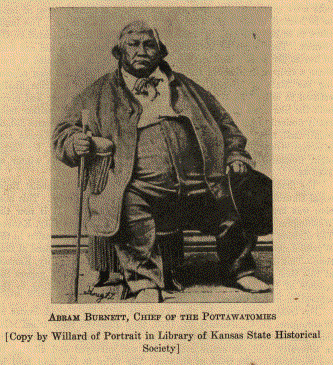 ABRAM BURNETT, CHIEF OF THE POTTAWATOMIES [Copy by Willard of Portrait in Library of Kansas State Historical Society] |
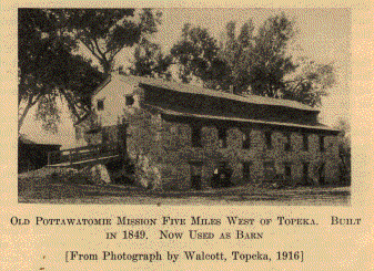 OLD POTTAWATOMIE MISSION FIVE MILES WEST 0F TOPEKA. BUILT IN 1849. NOW USED AS BARN [From Photograph by Walcott, Topeka, 1916] |
In June, 1846, a treaty was held with the two divisions of the tribe. It was concluded at the Pottawatomie Agency, near Council Bluffs, on the 5th day of June with the Iowa or Prairie band; and on the 17th of June with the Kansas band, on. Pottawatomie Creek. In this treaty there was an attempt to bring together the tribes formed by the ancient division of the Pottawatomies. It provided that the various bands of the Pottawatomie Indians, known as the Chippewas, Ottawas, and Pottawatomies, the Pottawatomies of the Prairie, the Pottawatomies of the Wabash, and the Pottawatomies of Indiana, being the same people by kindred, by feeling, and by language, should unite and be consolidated into one people to be known as the Pottawatomie Nation. Their Kansas and Iowa lands were ceded to the United States. In lieu of these lands they were assigned a new reservation in Kansas, described as follows:
"A tract or parcel of land containing five hundred and seventy-six thousand acres, being thirty miles square, and being the eastern part of lands ceded to the United States by the Kansas tribe of Indians, lying adjoining the Shawnees on the south, and the Delawares and Shawnees on the east, on both sides of the Kansas River."
This tract was the east thirty miles of the old Kansas Indian reservation. It lay immediately west of Topeka, and it comprises one of the most fertile tracts in Kansas. The Pottawatomie Nation was to move to this new reservation within two years, and certain annuities were to be paid the individuals of the Nation one year after they had settled there. The Kansas band began to move almost immediately, but it was the full two years before the Nation had assembled on the Kansas River. Some of the Kansas band settled west and southwest of Topeka. There the Baptists established a Mission, some of the buildings of which still stand.
|
|
The Catholics also founded a mission among them. This mission was at the junction of the three forks of the Wakarusa. It had been commenced on Sugar Creek, on the old first Kansas reservation, in 1837, by Father Christian Hoecken. He came north with one of the first parties, and in 1847 began the erection of mission buildings at the forks of the Wakarusa, in 1847. Some twenty log cabins were erected at that point. It was soon discovered that the mission was south of the reservation line, and on the Shawnee land. As the Pottawatomies could not collect their annuities until they had moved on to their own land, they abandoned their houses and moved north of the Kansas River. The Catholic Fathers established themselves at a beautiful site, now the town of St. Mary's. The mission has grown into one of the principal Catholic institutions of the West.
While the Pawnees had agreed to retire beyond the Platte as early as 1834, they seem to have been possessed of a determination to hold the valley of the Kansas River. No sooner had the Pottawatomies settled themselves about the mission at St. Mary's than the Pawnees began attacks upon them, intending to expel them, or at least hoping to make the new home so uncomfortable the Pottawatomies would abandon it. But the old Algonquian stock was ever courageous. The Pottawatomies accepted the challenge. They declared war on the Pawnees, and dug up the tomahawk. The Pawnee force was camped along the Big Blue, down which stream they always came to make war on the enemies in the valley of the Kansas. The Pottawatomies attacked at the Rocky Ford, in what is now Pottawatomie County. A fierce skirmish ensued, in which the superior firearms of the Pottawatomies gave them the advantage. While the Pawnees were not defeated, they did retreat from the field, passing westward to Chapman's Creek, where they made a stand. There they had a better country for the free movements of their horses, in their peculiar tactics. The Pottawatomies pursued, and when they came up with their foes a considerable battle ensued. The Pawnees had only horsemen, and at the Rocky Ford only mounted Pottawatomies had engaged them. The Pottawatomies had determined to settle once for all whether they could live on the Kansas, and had mustered their full strength, many on foot. These latter were stationed in some short bushy ravines under a high steep bank The Pottawatomie horsemen so maneuvered that the Pawnees were drawn down the prairie along these gullies, when the Pottawatomie footmen lying in ambush there opened fire. The Pawnees were taken by complete surprise. Several of their foremost warriors were slain, but they did not give up the battle, which was fiercely contested with the mounted Pottawatomies, who were now much encouraged. They charged the Pawnees repeatedly, finally putting them to flight. The Pawnees disappeared northward over the prairies, and never more made a foray below the Big Blue. The Pottawatomies were never more molested by them. They lost some forty warriors in this effort to drive out the Pottawatomies. For many years a Pottawatomie chieftain who had distinguished himself in this campaign would decorate himself in true warrior style on the anniversary of the battle and ride to the western and northern boundary lines of the reserve to celebrate the victory and satisfy himself that their frontiers were clear.
The Pottawatomies have the social organization found in the tribes of the Algonquian family. The clans or gentes of the tribes are as follows:
| Wolf. | |
| Bear. | |
| Beaver. | |
| Elk. | |
| Loon. | |
| Eagle. | |
| Sturgeon. | |
| Carp. (Golden Carp.) | |
| Bald Eagle. | |
| Thunder. | |
| Rabbit. | |
| Crow. | |
| Fox. | |
| Turkey. | |
| Black Hawk. |
The Pottawatomies made a treaty in 1862 under which the greater portion of their reservation was disposed of. There was a disagreement in the tribe on the subject of land. The Prairie band refused to accept their land in severalty, and severed their relations with the other bands. They were given a reservation in common eleven miles square in Jackson County, Kansas, a part of the old home tract, and now reside upon it. It was provided that the other bands should or might become citizens of the United States and have their lands allotted to them. There was a surplus after the allotment, and this went through the usual process of graft in the final extinction of the Indian title.
In 1868 the Citizen Pottawatomies secured a reservation in what is now Oklahoma, to which they moved, and where they now live.
The Cherokees belong to the Iroquoian linguistic family. No Indians in North America have a more interesting history. In prehistoric times they lived in what is now the State of Ohio, where they erected many mounds and other earthworks. Other tribes expelled them from the Ohio country. They retreated from the Ohio River up the Kanawha, settling about the headwaters of that stream and the Tennessee. They also claimed the country extending far down into Carolina, Georgia and Alabama. They were virtually expelled from their Eastern home by the United States, and were given a reservation in what is now Oklahoma, where they now live. They were one of the large tribes. The seven millions of acres there did not seem to satisfy them as to quantity of land. In 1836 they purchased the Osage lands known as the "buffer" tract, lying immediately east of the Osage reservation. The tract contained eight hundred thousand acres, and the Cherokees paid five hundred thousand dollars for it. But they never occupied the land. The tract came to be known as the Cherokee Neutral Lands.
On July 19, 1866, this tract was ceded to the United States to be sold for the benefit of the tribe. The Cherokee Nation joined the Southern Confederacy in the Civil War. If this act had any binding force, then this eight hundred thousand acres of Kansas land was technically, at least, a portion of the Southern Confederacy during the Rebellion.
It was at length determined that the South boundary of the Osage reserve was not the thirty-seventh parallel. The Osage line was found to be about two and one-half miles north of that parallel of latitude. As the north line of the Cherokee land - from the west line of this eight hundred thousand acre tract - was the south line of the Osage land, there remained the strip between the Osage line and the Kansas State line belonging to the Cherokees in Kansas the full length of their outlet. This treaty provided for the sale of this narrow strip also for the benefit of the Cherokee tribe.
None of these Indians ever lived in Kansas. The only reason for their appearance here is the fact that they owned a portion of the soil of the State. Their mention will require but a brief space.
The tribes coming under this head are as follows: Senecas, Cayugas, Tuscaroras, Oneidas, St. Regis (of Iroquoian stock), Stockbridges, Munsees. and Brothertons. The last three tribes are of the Algonquian stock. Through the frauds practiced on these Indians by certain State Governments they were cheated out of their lands in the State of New York. By the treaty of 1838 they were given a tract in Kansas. This tract was laid off immediately north of the Osage reservation, about twenty miles broad (nineteen, in fact) by about one hundred and ten miles long. It contained one million eight hundred and twenty-four thousand acres. The treaty provided that each individual of these tribes should be allotted three hundred and twenty acres upon application. Only thirty-two persons ever made such application, Provision was made for the sale of these allotments for the benefit of the allottees. The remainder of the reservation was declared forfeited to the United States because of non-occupancy, the Indians refusing to move west. The legal status of the land and the compensation for the Indians required years for settlement, and the matter was finally decided by the courts. The reservation was restored to the public domains in 1860, by President Buchanan.
The Kickapoos were first mentioned in history about 1670, when they were found about the water-shed between the Wisconsin and Fox rivers. That region seems to have been their prehistoric home. They drifted to the southward in historic times, finally stopping on the Sangamon and Wabash rivers. Those dwelling on the waters of the Wabash had their town on the Vermilion River, and from that circumstance came to be called the Vermilion band. Those to the westward were known as the Prairie band. All of them were followers of Tecumseh, and many of them fought under Blackhawk in his war against the United States. The Government employed one hundred of them to go to Florida, as soldiers. There they fought the Seminoles, in 1837. In 1852 a considerable number, with some Pottawatomies, went to Texas. Later they went on to Mexico, where they have a reservation east of Chihuahua, in the Santa Rosa Mountains.
The first removal of the Kickapoos was to the State of Missouri, living there on the Osage River. By the treaty of October 24, 1832, they were assigned the following lands now in Kansas:
"Beginning on the Delaware line, six miles westwardly of Fort Leavenworth, thence with the Delaware line westwardly sixty miles, thence north twenty miles, thence in a direct line to the west bank of the Missouri, at a point twenty-six miles north of Fort Leavenworth, thence down the west bank of the Missouri River, to a point six miles nearly southwest of Fort Leavenworth, and thence to the beginning."
They were all gathered on this reservation in due time. In 1854 this reservation was given back to the United States, excepting a tract containing one hundred and fifty thousand acres on the head of the Grasshopper River retained for a future home. Much of this diminished reserve was lost through grafters and railroad promoters. Only sixty-four hundred and sixty-eight acres remain. This tract is held in common to this time and is the home of those still in Kansas.
The Iowas are of the Siouan family, but here we find them confederated with two tribes of the Algonquian stock. The Iowas claim to be an offshoot from the Winnebagos. They were the wanderers of the Siouans, and have lived in Missouri, Minnesota, Iowa, and some of them have lived in Nebraska. This was before they were settled in Kansas. At one time they lived on the Missouri River opposite the site of Fort Leavenworth. The name signifies "The Sleepy Ones." Their social organization is similar to that of other Siouan tribes. There are two phratries, each having four gentes:
| First phratry: | |
| 1. | Black Bear. |
| 2. | Wolf. |
| 3. | Eagle and Thunder-being. |
| 4. | Elk. |
| Second phratry: | |
| 5. | Beaver. |
| 6. | Pigeon. |
| 7. | Buffalo. |
| 8. | Snake. |
There was an Owl gens, but it is extinct.
In 1830 the confederacy of which the Iowas were a tribe consisted of the Sacs, Foxes, Iowas, Omahas, Missouris, Otoes, and Sioux.
The Sacs, or Sauks, are one of the first of the Western Algonquian tribes seen by the Europeans. Their Indian name signifies "Yellow Earth People." They were said to be more savage than neighboring tribes - forest vagabonds and wanderers. Their prehistoric home was about the south shore of the Great Lakes, probably in Michigan. It is said that "they could not endure the sight of the whiskers of the Europeans," killing those of their captives who wore them. They were active in the wars among the Indian tribes, and suffered accordingly. In 1804, at St. Louis, one band of the Sacs made a treaty ceding all the lands of the Sacs and Foxes in Wisconsin, Illinois, and Missouri. This act enraged the other portion of their tribe, and the Foxes. In fact, it was resented by all the tribes of those regions, and was one of the causes of the Blackhawk War. The band committing this crime against the tribe was later called the Missouri River Sacs. A band of Sacs once lived on the Osage River, in Missouri.
The Blackhawk War almost destroyed the Sacs and Foxes. They came together in Iowa, where they soon regained their prowess, making war on a number of tribes, expelling the Sioux from that territory.
The Foxes were the Red Earth People. They were first met along the Red River, in Wisconsin, and on Lake Winnebago. They were fierce warriors, and their Indian neighbors said they were stingy, moved by avarice, thieves, and always turbulent and quarrelsome. From their first acquaintance with Europeans they were closely associated with the Sacs. Their migrations and history are practically the same.
By the year 1836 the confederacy of which the Sacs and Foxes were a part seems to have retained only themselves and the Iowa. On the 17th of September of that year these made a treaty with the United States by which they were given a reservation lying immediately north of that of the Kickapoos in Kansas and Nebraska. Thither the confederacy of the three tribes migrated. There dissensions arose between the Sacs and Foxes due to the intrigues of Keokuk. They maintained separate villages. While the Foxes were absent on a buffalo hunt, about 1857, the Sacs made a treaty providing that the Sacs and Foxes should accept their lands in severalty and sell the surplus. This treaty was fomented by thieves and grafters. The Government is always beset with an unsavory rabble - scoundrels and scalawags - who make themselves useful politically. For their services they intrigue and plan larcenies of anything from a public document to an Indian reservation. If their transactions become a public scandal the Government repudiates them. If their plans do not arouse too much adverse sentiment, the Government permits them to mature, and the dishonest officials take a portion of the loot.
The Foxes would not be bound by the treaty, and their chief was deposed, an action the Foxes did not agree to. The chief and most of the Foxes went to Iowa, where some of their tribe had always lived. In 1854 some Foxes had slain a number of Plains Indians in battle while on a buffalo hunt, and fearing punishment by the Government, had gone back to Iowa. These Foxes bought a small tract of land on the Iowa River upon which they settled. This small reservation is in Tama County, and has been increased until it contains three thousand acres.
By the treaty of May 17, 1854, the reservation secured to the Iowas in 1836 was decreased. The confederacy had ceased to exist, so the Iowas made their own terms with the Government. They accepted a small tract about the mouth of the Great Nemaha as their future home. The residue of their lands were sold for their benefit. June 5 to 9, 1857, these lands were sold at Iowa Point. They comprised some of the best lands in Brown County.
On the 18th of May, 1854, the Government concluded a treaty with the Sacs and Foxes. They disposed of all their lands except fifty sections, which were to be selected within six months. Some eight thousand acres yet remain to members of those tribes who chose to remain there. Most of the Sacs went to what is now Oklahoma in 1867.
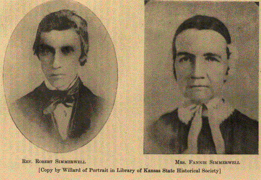
The Presbyterians established a mission among the Iowas while they dwelt yet in Missouri. Samuel M. Irvin and his wife were the first missionaries. They came with the Indians to the new reservation, arriving in 1837. The site of the future mission was fixed at a point about two miles east of the present town of Highland, in Doniphan County. The first building erected was a log cabin. In 1845 the Presbyterian Board of foreign missions erected a brick mission building to replace the log cabin and other temporary structures. The new building was one hundred and six feet long by thirty-seven feet wide, three stories in height, and contained thirty-two rooms. This structure was standing as late as 1907, but it was much damaged by a tornado in that year - practically destroyed, in fact.
The history of the Sacs and Foxes of the Mississippi is the same as that of the Missouri portion of the tribes, except that they had never wandered so far from the ancestral home. They lived nearer the Mississippi River, and the other band lived on the Missouri River - or the Osage, a branch of the Missouri, and from these circumstances came the names of the two bands. One band was the Sacs and Foxes of the Mississippi, and the other the Sacs and Foxes of the Missouri.
The Sacs and Foxes of the Mississippi owned and held about three-fourths of the State of Iowa up to the year 1842. On the 11th day of October of that year they ceded that magnificent domain to the United States. They were to be given another reservation "upon the Missouri River, or some of the waters." They were given a tract of land thirty-four miles long by about twenty miles wide on the Marais des Cygnes west of the present town of Ottawa, Kansas. They did not arrive in Kansas until 1846. By January 1, of that year all the Sacs and one-fifth of the Foxes were on the Wakarusa. They were permitted to stop there by the Shawnees until the remainder of the Foxes could be present, when the reservation was to be selected. The missing Foxes were visiting the Pottawatomies. In the Spring those assembled on the Wakarusa selected the reservation, not wishing to wait longer. Those on the Wakarusa numbered something less than one thousand. They finally took up their residence about the point where Lyndon was later founded.
October 1, 1859, these Indians made a treaty by which all their lands lying west of the rangeline of range sixteen, about three hundred thousand acres, were to be sold for their benefit. This left them about one hundred and fifty-three thousand acres. A strip of these trust lands six miles wide lay in Franklin County, Kansas, and was soon the prey of "speculators," as they were called. One of these was John P. Usher, Secretary of the Interior in the Cabinet of President Lincoln, and who long lived at Lawrence, Kansas. These Indians were soon made the victims of a fraud. One Robert S. Stevens was in various very questionable schemes in Kansas in the early days. By some devious connection with the Indian Department he was employed to build for these Indians one hundred and fifty little stone houses on the lands remaining to them. They did not want these houses, and protested against the waste of their money for any such purpose. But their protests were unheeded at Washington. The grafters had the ear of the Government, as usual, and the Indians were robbed. This same Stevens worked the identical scheme on the Kansas Indians, on the Council Grove reservation. All these Indians, as soon as the little stone houses were completed, sold the doors, windows, and floors for whiskey, and stabled their ponies in the dilapidated ruins. They would not live in such houses.
The divestment of these Indians of the residue of their lands ran the usual course of fraud. The allotment plan was brought into play, and the cunningly devised chicanery wound their devious ways. They were given seven hundred and fifty square miles of land, supposed to be worthless, in what is now Oklahoma. In 1867 they began to migrate to that tract, and in a period of five years they were mostly living on it.
The Methodist Episcopal Church, South, did some missionary work among the Sacs and Foxes before the Civil War. In 1860 the Methodist Episcopal Church appointed Rev. Richard P. Duvall missionary to this tribe. He began his labors at the tribal agency at once. April, 1863, he opened the mission school. This was in two large buildings distant about a mile from the agency. In 1862-63 some of the tribe sent their children to Baker University, at Baldwin. No great progress was ever made in the work of Christianizing the Sacs and Foxes.
| 1918 Kansas and Kansans | Previous Section | Next Section |
A Standard History of Kansas and Kansans , written and compiled by William E. Connelley, transcribed by Carolyn Ward, 1998.
![]()
