History of Butler County
CHAPTER I.
ORGANIZATION.
NAMED IN HONOR OF ANDREW P. BUTLER EARLY INFLUENCE INDICATED IN NAME ONE OF THE ORIGINAL THIRTY-THREE COUNTIES FIRST AND LATER BOUNDARIES FIRST COUNTY SEAT TOWNSHIP BOUNDARIES ORGANIZATION OF TOWNSHIPS DISTRICTS TOPOGRAPHY PRODUCTS HERD LAW FENCES.
Butler county was named in honor of Andrew P. Butler, for twelve years United States Senator from South Carolina.
Andrew Pickens Butler lived from 1796 to 1857. He was prominent in politics and an active worker for the cause of the South. He served in the Legislature in 1824, and was appointed judge of the circuit and supreme courts in 1833. In 1846, he was appointed United States Senator and served until his death. Senator Butler was attacked with great severity by Senator Sumner in his speech, "The Crime Against Kansas." Butler was absent from the Senate at the time, but Preston S. Brooks, a relative who was present, later mortally assaulted Sumner.
Senator Butler was a zealous advocate of the right of the South to introduce slavery into the Territory of Kansas. The naming of this county after an ardent southern sympathizer is an echo of the spirit of the times. Many of the counties of the original organization were similarly named, this being the Missouri influence working itself out in the "Bogus Legislature." Thus were named Davis, Wise, Lykins, Douglass, Jefferson, Calhoun, Bourbon, Breckinridge, Franklin, Weller, Anderson, Dorn, McGee and Godfrey counties. The names of some of these counties were changed in later years, while others still retain the original name, as does Butler county.
Butler, the largest county in area in Kansas, is located in the southern part of the State, east of the center, it being in the second tier of counties from the south line, and in the fifth tier west from the east line of the State.
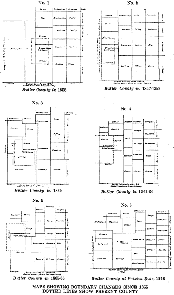
Butler county was established in 1855, by the first territorial legislature, which met at Pawnee, on the Kansas River, 145 miles west of
| 34 | HISTORY OF BUTLER COUNTY |
Westport, Mo. After its organization the legislative body removed to the Shawnee Manual Labor School in Johnson county—this school was established in 1831. This legislature was known as the "Bogus Legislature" on account of its being convened and run by men from the State of Missouri.
At this session the territory was divided into thirty-three counties.
Thus Butler county is one of the original counties created by the first legislature of the Territory of Kansas.
The boundaries of Butler county as defined in the creative act as follows: "Beginning at the southeast corner of Wise county (the present Morris county); thence running south thirty miles; thence west thirty miles; thence north thirty miles; thence east thirty miles to the place of beginning." This giving the county an original area of 900 square miles.
The county at that time was attached to Madison county for civil
BUTLER COUNTY COURT HOUSE, EL DORADO, KANS.
and military purposes—(see map No. 1.) The same legislative act of 1855 designated the region immediately south of the original Butler, a tract thirty miles east and west, and about seventy-eight miles north and south, to the southern boundary line of the territory, as Hunter county.
In 1857 the boundaries were changed by legislative act. This act
| HISTORY OF BUTLER COUNTY | 35 |
made Butler county consist of a tract thirty miles wide, directly south of Wise (Morris) county, extending southward thirty-eight miles. Hunter was made to consist of the section south of Butler to the territorial line.
On February 11, 1859, Butler county was organized. The legislature was then in session at Lecompton, Samuel Medary being governor. Governor Medary from Ohio was the ninth, or next to the last territorial governor.
This act included the organization of Wise and Chase counties. Chase was made of the region south of Wise, twenty-four miles by thirty miles east and west. The fifth standard parallel, near the west branch bridge on North Main street, El Dorado, was the south boundary line of Butler county.
Chelsea was then the county seat of Butler, while old El Dorado was in Hunter county. This first location of El Dorado was south and west of the present El Dorado. The original site included what is now known as the Royce farm, the C. C. Jamieson farm, the West cemetery, and a portion of the land now owned by Mrs. Mary White, mother of William Allen White. The land was platted but not filed, there being no filing office near at that time.
February 27, 1860, Irving county was made out of the region commencing where the fifth standard parallel and guide meridian cross, between ranges 8 and 9, west thirty-six and north twenty-four miles. El Dorado was the temporary county seat.
On February 24, 1864, the boundaries were once more changed. It was said an early settler had either to be a surveyor, or employ one permanently in order to keep informed of the changes in the boundaries. The boundary lines as described by the act of 1864 were as follows: Commencing at a point twelve miles west of the present northeast corner of Harvey county; thence south to the south line of the State; thence east to a point nine miles east of the present southwest corner of Chautauqua county; thence north to the southeast corner of Chase county; thence west twenty-four miles; then north six miles; thence west to the place of beginning.
This description covered a strip twelve miles wide on the east side of Harvey, Sedgewick and Sumner counties, all of Cowley county, and a strip nine miles wide on the west side of Chautauqua, Elk and Greenwood counties, and three townships in the southwest corner of Marion county. Thus including the territory now occupied by Newton, Wichita, Belle Plaine, Oxford, Winfield, Arkansas City, Cedarvale, Grenola, Reece, Burns and Peabody.
During this period Chelsea was the county seat. Thomas Carney was then governor. Governor Carney was the second governor after the State was admitted to the Union.
The act providing that Butler county should include all this territory was repealed in 1867. On February 26, of that year, by legislative act Butler county was given its present form.
| 36 | HISTORY OF BUTLER COUNTY |
Jerry D. Connor, prominent early settler, was a member of the legislature at that time. (See maps 2, 3, 4, 5, 6).
So that today the county is bounded on the north by Marion and Chase counties; on the east by Greenwood and Elk counties; on the south by Cowley county, and on the west by Edgwick[sic] and Harvey counties. A description of its location is as follows:
Beginning at the northeast corner of section 4, township 23, range 8, east of the sixth principal meridian; thence running west to the northwest corner of section 6, township 23, range 3, east; thence south to the southwest corner of section 31, township 29, range 3, east; thence east to the southeast corner section 33, township 29, range 8, east; thence north to the place of beginning.
From north to south it stretches forty-two miles, and from east to west thirty-four and a half miles; making a total area of nearly 1,000,000 acres, or 1,440 square miles.
Butler county is larger than the State of Rhode Island, while its arable land amounts to nearly as much as that of two of the smaller eastern states. Thus it may well claim its name, the "State of Butler."
August 23, 1867, Butler county was divided into the townhips[sic] of Chelsea, El Dorado, Walnut and Towanda. The boundaries given to these townships are described as follows:
Chelsea, township: Commencing at the northwest corner of section 19, township 25, range; thence east to county line; thence north to northeast corner of the county; thence west to range line between ranges 4 and 5; thence south to the beginning.
El Dorado township: Commencing at the northwest corner of section 19, township 25, range 5; thence south nine miles; thence east six miles; thence south two miles; thence, east fifteen miles to the east line of the county; thence north eleven miles; thence west twenty-one miles to the place of beginning.
Walnut township: Commencing at the southeast corner of El Dorado township; thence west to the west line of the county (thence east to point south of the beginning, omitted from the records); thence north to the beginning.
Towanda township: Commencing at the southeast corner of section 12, township 27. range 4; thence west to the county line; thence north to the north line of the county; thence east to the range line between ranges 4 and 5; thence south to the place of beginning.
From these four original townships were drawn the remaining townships of the county, they having been divided and subdivided, parts added and detached to finally form the twenty-nine townships which now comprise the county.
The names of the townships of Butler county, with the date of organization, are given below:
Augusta township: Organized in 1870 from parts of El Dorado and Walnut. In 1872, part detached to form Spring. In 1873, parts de-
| HISTORY OF BUTLER COUNTY | 37 |
tached to form Bruno and Pleasant. In 1874, parts detached to form Bloomington.
Benton Township: Organized in 1872 from part of Towanda.
Bloomington township: Organized in 1874 from parts of Augusta and Walnut.
Bruno township: Organized in 1873 from part of Augusta.
Chelsea township: Organized in 1876 in the original division of the county into townships. In 1876, part detached to form Clifford. In 1878, part detached to form Sycamore. In 1879, parts detached to form El Dorado and Lincoln.
Clay township: Organized in 1879 from part of Walnut.
Clifford township: Organized in 1876 from parts of Chelsea and Towanda.
Douglass township: Organized in 1874 from part of Walnut.
El Dorado township: Organized in 1867, in the original division of the county into townships. Parts detached in 1877 to form Glencoe, Little Walnut, Prospect and Rosalia. In 1879, part of Chelsea attached.
Fairmount township: Organized in 1873 from part of Towanda.
Fairview township: Organized in 1873 from part of Towanda.
Glencoe township: Organized in 1877 from parts of El Dorado and Walnut.
Hickory township: Organized in 1875 from part of Walnut.
Lincoln township: Organized in 1879 from part of Chelsea.
Little Walnut township: Organized in 1877 from parts of El Dorado and Walnut.
Logan township: Organized in 1874 from part of Walnut.
Milton township: Organized in 1873 from part of Towanda.
Murdock township: Organized in 1873 from part of Towanda.
Pleasant township: Organized in 1873 from parts of Augusta and
Plum Grove township: Organized in 1873 from part of Towanda.
Prospect township: Organized in 1877 from part of El Dorado.
Richland township: Organized in 1874 from part of Walnut.
Rock Creek township: Organized in 1879 from part of Walnut.
Rosalia township: Organized in 1874 from part of El Dorado.
Spring township: Organized in 1872 from part of Augusta.
Sycamore township: Organized in 1867 in the original division of the county into townships. Part detached in 1870 to form Augusta. Part detached in 1872 to form Benton. Part detached in 1873 to form Fairmount, Fairview, Milton, Murdock and Plum Grove. Part detached in 1867 to form Clifford.
Union township: Organized in 1879 from part of Walnut.
Walnut township: Organized in 1867 in the original division of the county into townships. In 1870, part detached to form Augusta. In 1873, part detached to form Pleasant. In 1874, part detached to form Bloomington, Douglass and Richland. In 1875, part detached to form
| 38 | HISTORY OF BUTLER COUNTY |
Hickory. In 1877, parts detached to form Glencoe and Little Walnut. In 1879, parts detached to form Clay, Rock Creek and Union.
March 21, 1860, the county was divided into three commissioners districts.
These districts were to include the territory described in the records as follows:
District No. 1: Township 22, of ranges 5, 6, 7, 8, 9 and 10; township 23, of ranges 6 and 7, and one mile off of the north side of township 25, of ranges 6 and 7.
District No. 2: Townships 23, 24 and 25. of range 5, and five miles off of the south side of township 25, of ranges 6 and 7.
District No. 3: Townships 23, 24 and 25, of range 8; townships 23, 24 and 25, of range 9, and townships 23, 24 and 25, of range 10.
September 4, 1871, the first division of the county into commissioners districts by townships was made. According to this division the districts were thus designated:
First district: The townships of Augusta, Towanda and Plum Grove.
Second district: The townships of El Dorado, Chelsea and Rosalia.
Third district: The townships of Little Walnut, Union, Walnut and Spring.
As now constructed the commissioners districts of Butler county include the townships as given in the following:
First district: Union, Hickory, Logan, Clay, Rock Creek, Bloomington, Spring, Augusta, Walnut, Douglass, Richland and Pleasant.
Second district: Glencoe, Rosalia, Prospect, El Dorado and Little Walnut.
Third district: Chelsea, Sycamore, Lincoln, Fairmount, Clifford, Milton, Plum Grove, Fairview, Murdock, Benton, Bruno and Towanda.
Butler county is a confine of almost a million acres of prairie land, a considerable portion of which is of rolling character. It has an elevation of from 600 to 1,200 feet. The surface ranges from the broad level or rolling lands in the western part to broken and rough places in the eastern part, with a line of rugged hills on the extreme east border. These belong to the range known as the Flint Hills, an irregular, picturesque, line of hills, that a man standing on their limestone capped summit, inhaling Kansas ozone, and surveying the peace and wealth of the valleys, holds his head a little higher and breathes a little deeper in pride of home and possessions in Butler county.
There is very little waste land as the soil is fertile and productive, heavier or deeper on the bottom lands and is adapted to the growth of almost every variety of grain and fruit. The river and creek bottoms comprise about one-fifth of the area and range from a mile to two miles in width.
The timber is confined to the bottom lands along the streams, varying from a few rods to a mile in width. The trees native to the county are the oak, cottonwood, walnut, hackberry, white hickory, sycamore, elm, mulberry and some scattering varieties.
| HISTORY OF BUTLER COUNTY | 39 |
The principal streams are the Walnut and the Whitewater. The Walnut rises in the northeast corner of the county. The Whitewater traverses the county from the northwest, flowing into the Walnut at Augusta. These streams have many smaller tributaries. The principal ones are the West Branch, Little Walnut, Bemis, Bird, Cole, Dureckon, Eight-Mile. Muddy, Satchel and Turkey creeks, tributaries to the Walnut; and the West Branch, Elm, Dry, Diamond, Four-Mile, Rock, Went-
WHITEWATER FALLS.
worth and Bakers creeks, tributaries to the Whitewater. These streams and tributaries make Butler one of the finest watered counties in Kansas.
Corn, oats, rye, winter wheat, feterita, kafir corn, sorghum, alfalfa and prairie hay are the crops grown. The county ranks first in acreage and value of the four latter named.
The large pastures in the eastern part of the county make live stock raising of importance. These pastures contain some of the finest cattle in the world. Also at the present time, Butler county leads the State in numbers and value of animals sold for slaughter.
| 40 | HISTORY OF BUTLER COUNTY |
Fruit growing receives more or less attention over the county, there being now planted several hundred thousand trees of fruit-bearing age. An abundance of limestone is found in the soil of this county. This has been quarried extensively and large quantities of stone have been shipped to various places.
At first, fences, usually rail, laid without nails, were placed around crops in small fields.
In 1871, what is known as the "Herd" law was enacted. This was adopted in this county at an election in April, 1871. The election resulted in 569 in favor of the adoption of the law, and 504 against. Martin Vaught, B. T. Rice and Neil Wilkie were the county commissioners at that time.
The law was designed to cause cattle men to fence or herd their stock—this instead of the farmer fencing his crops.
The law met with considerable opposition, especially from those who had some fencing on their farms and who had been turning their stock out to graze, letting them go until wanted.
By this time there were quite a number of settlers on the uplands. These had no fencing material and no means of securing any. They could look after their stock more easily than they could fence their crops. And so came the need for the "Herd" law.
This law has never been repealed. It is, of course, without resistence in the present day.
After the law was enacted hedges began to be planted and fences were started in that manner. The selling of hedge plants, with wonderful guarantees of growth, became a popular industry at this time.
While the hedges were growing into lawful fences recourse was had to rope. Stock of all kinds was "lariated," that is, tied to the end of about fifty feet of rope, the other end being fastened to a picket pin which was driven into the ground. Picket pins in those days were a staple article of trade in all stores. They were made with a swivel, to which was attached the rope, and so prevent twisting. Rope was purchased by the carload by the merchant, and bought by the coil by the farmer.
It was not an uncommon thing to see children, chickens, pigs, cows and horses attached, each to one end of a lariat, with a picket pin holding securely the other end. Sometimes a picket pin would disappear—and also a horse likewise.
As time passed on the hedges grew to serve the purpose of their planting. These hedge fences were undoubtedly of some benefit to the early Kansas farmer. They served not only as pasture enclosures, but were a protection to the treeless, wind-swept prairies. Later the hedge fence came to be regarded as more or less undesirable, and in late years has been largely cut down.
After the hedge fence came the barbed wire, which is now in universal use, and on which the farmer of today depends in the management of his broad pastures and many cattle.
Previous | Main Page | Biography Index | Next
Pages 33-40.
![]()
Transcribed by Carolyn Ward from History of Butler County, Kansas by Vol. P. Mooney. Standard Publishing Company, Lawrence, Kan.: 1916. ill.; 894 pgs.
Locations:
A-H | I-Il | In-Iz | Kansas(A-D) | Kansas(E-J) | Kansas(K-R) | Kansas(S-Z)-Kz | L-M | N | O | P-Z |
A | B-Bn | Bo-Bz | C-Cn | Co-Cz | D | E | F | G | H-Har | Has-Hn | Ho-Hz | I | J | K | L |
M-Md | Me-Mz | N | O | P | Q | R | S-She | Shi-Sn | So-Sz | T | U | V | W-Whe | Whi-Wz | Y | Z
