PIONEER HISTORY OF KANSAS
by Adolph Roenigk
CHAPTER XXXII
VISITING INDIAN BATTLEFIELDS
A Surprise and Destruction of a Peacable Band of Indians;
Beecher Island’; Monument Erected by Kansas and Colorado;
Annual Celebration Held on the Former Battleground; Looking
for the Battlefield of Summit Springs; Julesburg and the Site
of Fort Sedgwick.
It has been my desire for some years to visit three Indian battlefields, all of which are located in the northwestern part of the state of Kansas, and the northeastern part of Colorado. They are at a distance of about seventy miles from each other.
In order to see them one must go overland from one railroad to another. The first battlefield I wish to describe is located in the south part of Rawlins County. Outside of the members of the Kansas State Historical Society very few people have ever heard of it. A description of the fight that took place here is given below.
At the beginning of May, 1922, I took the train at Lincoln for Colby, Thomas County, and arrived there at night. I had with me a map giving the location of the battle field noted, but no other information, as to how to get there. The next morning I learned of a hackline running from this city to Atwood, the County Seat of Rawlins County, thirty miles north. The battlefield site on my map showed it to be four miles east of this route. I made inquiry at the printing office, but although the distance to the battle field was only twelve miles, I found no one who could give me any other information. Finally the hack driver, an obliging sort of man, figured out the way for me during our journey. He let me off at a farm house nearest to this point. The owner of this farm knew about the Indian battlefield and directed me to the place, which was located three and a half miles east of his farm.
The farm on which the battle field was located was occupied by a young farmer named Leslie Koontz. He was the son of the man who owned the place and who had homesteaded the quarter section in 1878, three years after this Indian fight had taken place. This farm had not changed since that time; but Mr. Koontz, Sr., getting up in years, had retired from the farm, moved to the town of Colby, and turned the farm over to his son. When I arrived, Leslie Koontz, not being busy, and being of a very obliging disposition, guided me over the place and told me what he knew about the battlefield. Leslie was born
252
on the farm, and had lived there all his life. When a boy he picked up many Indian relics. He said that among other things his father had found a full box of rifle cartridges, which the soldiers or hunters had overlooked or forgotten on the day of the battle. The account of this affair was written for the Kansas State Historical Society by William D. Street of Oberlin, Decatur County, and is recorded on page 368, Vol. 10, Kansas Historical Collections. Mr. Street is a prominent farmer and former member of the State Legislature. Only for Mr. Street investigating and writing up this matter, this part of our State’s history would have been forgotten and lost to history. I here give Mr. Streets account.
“Cheyenne Indian Massacre on the Middle Fork of the Sappa.”
“Early in the year, 1875, a band of Northern Cheyenne Indians, numbering about seventy-five persons all told, whose homes were with the Sioux in the vicinity of the Black Hills of Dakota, left the country of the Southern Cheyennes, in the Indian Territory, to make their way back north.
“They had been visiting their friends and allies in the south, and had probably assisted in the raids on the Texas border and skirmishes with the troops during the winter in that southland. They were proceeding in a tolerable orderly manner across the state of Kansas, about forty miles west of the frontier settlements, when on April 18, orders were issued to Austin Henely, Second Lieutenant of the Sixth United States Cavalry, to intercept and turn back the fleeing band.
“On the nineteenth the scouting party, consisting of forty men of Company H, Sixth Cavalry, with Homer W. Wheeler, post trader at Fort Wallace, as scout and guide, an engineer officer, a surgeon, and two teamsters, making a total of forty-six men, left Fort Wallace, Kansas, scouting southeast. On the divide between Twin Butte and Hackberry Creeks the Indian trail was discovered, leading northward.
“Pursuit was immediately commenced. The trail passed near Russell Springs, across the old trail of the Butterfield over land stage route, crossing the Union Pacific Railroad at a bridge about three miles west of Monument Station, in territory now embraced in Logan County. Thence the trail led northward.
“On the hard lands of the plateau between the Union Pacific and Sappa Creek, the Indians apparently divided, each lodge or family taking separate routes, to meet at some given
253
point further north, a favorite ruse of the Indians to throw pursers off the trail. After following a single trail for some distance, the pursuing party lost it entirely. The troops then marched northward toward Sappa Creek with the hope of picking up the trail again.
“While on the march, April 22, they met a party of three buffalo hunters, Henry Campbell, Charles Shroder and Samuel B. Srach. They informed Lieutenant Henely that the Indians were encamped on the north fork of the Sappa (more properly the middle fork of the Sappa).
“Under the guidance of the hunters, the troops pushed forward a few miles and went into camp until after sundown, when the march was continued to within a few miles of the supposed location of the camp. A halt was then made, and the scout and the hunters went forward to locate the Indians. Their efforts were successful, and in the gray dawn of the morning of April 23, 1875, the troops arrived at a point in the valley of the middle fork of the Sappa, about three-fourths of a mile below the camp. Herds of ponies were grazing close at hand. A small detachment of the command was detailed to kill the herders, and round up the ponies while the main body of the troops charged the village, located on the north side of the creek.
“The creek at this place was a wide sluggish marsh-like pond, several yards wide, the unusual width probably being caused by beaver dams. The creek here ran almost due east, until about opposite where the tepees were pitched it turned sharply to the south and slightly toward the west, making a large loop, or horseshoe bend, and running back to the northeast, and then meandering away on its general eastward course. Within a few rods of the camp to the east and northeast was located a low and rather abrupt bluff of a semi-circular formation, the southwestern edge of a long, regular tongue of land running down from the highlands and terminating with a gradual descent in the bend of the creek, and further east and south. The abrupt formation of the bluff near the camp had been caused by the action of the flood waters of the stream during ages past. Gullies had been furrowed on the western face of this bluff, making admirable places for protection of the Indian warriors, who soon took advantage of the location.
“The troops floundered through the muddy creek, dismounted and formed their line in the tongue of the land just
254
mentioned to the east and northeast of the Indian camp. While the ground on the south side of the stream was rugged and broken, the land to the northward sloped away with a gradual and fairly smooth rise. The troops occupied an exposed position on this smooth ridge. This position was abandoned after the loss of two men killed. The troops were then posted at each end of the semi-circular flat in which the Indian camp was located. This was greatly to the advantage of the troops, as it enabled them to pour a raking cross-fire into the camp and the low bluff where the warriors had sought protection, without such great exposure as the level ridge first occupied presented.
“The fight was furious from the start, and never ended while an Indian was left alive. Lieutenant Henely, in the report to his superior officers, says; “Nineteen dead warriors were counted, eight squaws and children were unavoidably killed by shots intended for warriors. This made a total of twenty-seven reported killed.
“White hunters who visited the scene a few days after the battle told the writer that they counted between thiry-five and forty dead bodies, and later two or three others were found a short distance from the scene of the fray, bringing the total above forty, men, women and children. Lying promiscuously around the burnt remains of their camp, while a number of bodies variously estimated up to twenty-seven had been thrown into a shallow sandy gully and partially buried by the troops, bringing the number that were really killed up to nearly seventy, which is not far out of the way. Lieutenant Henely reported the destruction of twelve lodges, and if we may estimate five Indians to the lodge the total would be sixty. He also mentions a number of holes that were dug in the ground, which he thinks were for the protection of Indians who had no lodges. His report as to the number killed does not harmonize with conditions as found a few days later.
“He says: “From the war bonnets and rich ornaments, I judge two were chiefs, and one, whose bonnet was surmounted by two horns, to be a medicine man. The Indians were nearly all armed with rifles and carbines, and Spencer carbines predominating.
“According to the report, the fight lasted about three hours. The camp, consisting of twelve lodges, together with the camp equipage and plunder was burned or destroyed, very little being retained. One hundred and thirty-four ponies were captured
255
by the troops, buffalo hunters later picking up several bands not rounded up by the soldiers.
“Lieutenant Henely makes no mention of the escape of any of the Indians and the inference would be that he thought he had completely wiped the band out of existence.
“But one Indian, and one only, made his escape. A young man without a family in the camp, and another older one, made a dash for their lives toward the north, up the long sloping hill. After getting a mile or more from the camp, and entirely out of range of the big buffalo guns the hunters were using in the fight, they halted and gazed back on the field of carnage, when the one with a family said to the other: “You are safe now, go on. I am going back to die with my family,”then wheeling his pony he rode back into the valley, and to his death. This information came to the writer several years after the fight, through Ben Clark, an interpreter for the Cheyennes, and at one time General Custer’s chief of scouts. He said to me, “The Cheyennes continue to sing praises of the hero who rode back to death with his family,” in that little valley far out on the Kansas frontier. Such a deed of valor deserves more than a passing word of notice, even if enacted by a child of the prairie.
“The three hunters mentioned before rendered good service as sharpshooters, their long-range sporting rifles carrying much farther than the soldiers’ carbines.
“It was a terrible tragedy enacted that April morning out on the Kansas plains, where women and babies met their deaths through the vicissitudes of war. One of the troopers afterward told at Buffalo Park that what was supposed to be a roll of plunder was carelessly tossed into the roaring fire of the tepees and tepeepoles, when an outcry told them that the roll contained a living human being, a little Indian papoose.
“The writer has frequently visited the scene of this massacre. On the first occasion within a short time after the fight. On several of these visits, in the early days, were plainly to be seen the evidences that Indians had but recently passed that way and paid their respects to their dead friends, leaving marks of various kinds to designate the names and the rank of their friends, and the place where they fell in the fight.
“The annihilation of this band was a severe and bitter blow to the Cheyennes. Whether they deserved such a fate, I am not prepared to judge, but on September 30 and October 1, 1878, (three years after the slaughter on the Sappa), a band of North-
256
ern Cheyennes, under the leadership of Chief Dull Knife, were endeavoring to escape from the Cheyenne reservation in the Indian Territory to their former home up among the Black Hills of the Dakotas, and to their friends the Sioux. They swung eastward in their flight and wreaked fearful revenge on the innocent white people who had pushed their settlements out onto the Sappa and Beaver Creeks in Decatur and Rawline Counties, where nearly forty unsuspecting men were killed, women outraged and a vast amount of property destroyed.
“So ended the last scenes of strife and carnage in the beautiful and famous Sappa valley.
“The massacre of the Cheyennes by Lieutenant Henely of the Sixth Cavalry, and the massacre of the white settlers by the Dull Knife band of Cheyennes, have always appeared to me to be closely connected in the annals of border warfare, now a closed book forever.”
Mr. Koontz took me to the site of the former Indian camp, to a spot where it was said a number of Indians were buried in a large hole. At this place where the ground was bare, and the rain washed away the soil, we still found a number of small beads. This may seem strange after a lapse of nearly half a century, but it is a fact nevertheless. While we were looking for beads, I saw some bones sticking out of the
NOTE: For the account see Page 577, Vol. 9, Kansas Historical Collections.
The following is an extract from Vol. 10, footnote Page 368: Lieutenant Henely’s report to the Secretary of War varies in many particulars from the account given by Mr. Street, and Hill P. Wilson, then a sutler at Fort Hays, in a letter to the Historical Society, says that at the time it was “understood that the least said about yhe affair the better for all concerned.”
Extract from footnote Vol. 10, 371: Hill P. Wilson in a statement concerning this fight , relates the following strange coincidence:
“Mrs. John Prower, of Las Animas, Colorado, until recently the wealthy widow of John Prower, the pioneer cattleman of the upper Arkansas, is a full-blooded Cheyenne woman. When Lieutenant Henely arrived at Fort Lyon, before leaving for Arizona, he had among his effects some of the paraphernalia of a medicine man of the Cheyenne tribe who had been killed in the fight. Medicine men are held in almost sacred consideration by all Indians. When Mrs. Prower saw these relics she ‘took on’ and went through the mourning ceremonies of the tribe. She kept up the crooning and wailing for three days and nights. Her mourning ended, she refreshed herself and made a prediction that the man who is responsible for the death of the medicine man will die within a year. By a strange fatality her prediction was in part verified. Henely was drowned in Arizona July 11, 1878. Although not strictly within the limitss of her prophecy, it would be hard to convince this untutored squaw that the Great Spirit had not intervened ultimately to avenge the death of the Medicine man.”
257
ground, and with a spade I unearthed thigh bones and other parts of an Indian’s skeleton.
From here Mr. Koontz took me to the hills on the south side of the creek, half a mile distant, where he said an Indian had been buried in a cave, in the rocks. We proceeded to the place. Along the bluffs there were ledges of rock with irregular caverns. In one of these, with an opening two or three feet high, the chief had been placed and the entrance then walled up with stone, not doubt to keep the wolves away. When the homesteader, Mr. Koontz, Sr., noticed this, and on investigation found it to be a burial place, he let the occupant rest in peace. The young man told me that this Indian skeleton remained there unmolested for many years, but finally a neighbor came and got it, and the last he knew it was still in his possession. Here, too, we found a number of beads, in two places, a few yards apart. Altogether, we picked up over seventy small beads which I still have in my possession. While we were looking for, and picking up the beads, the young man told me of an Indian skull he found in another small cavern, where a stone had been placed on top ot the opening. This, and the fact that beads were found in two separate places, seemed conclusive evidence that two Indians had been buried there, although only one skeleton had been found.
From the top of this bluff a full view of the vicinity of this former Indian camp was obtained. On account of the horseshoe bend of the creek, the description given by Mr. Street may be somewhat difficult for the reader to understand, but seen from this point the description of the location could not be improved upon. The statement that one Indian made his escape, and that other Indians later passed that way to pay their respects to their dead friends, also seems established. It may be possible, but not probable that this one escaped Indian returned to this destroyed camp, and carried these two Indian corpses a distance of half a mile, buried one in a cavern and then walled up the opening with stone. This performance appears to me to be the work of more than one Indian, and of course it must have been done shortly after the fight, but this problem must be left to the imagination of the reader.
The site of this former Indian camp is now enclosed in a pasture. Near it is a cattle yard, within a short distance of the farmhouse. Since these historic times, great changes have taken place here. The wild scenes of bygone days have disap-
258
peared. This farm is now in thorough cultivation. Several teams of horses are kept on the place, but the bulk of the field work is done with tractors and other kinds of modern machinery. A modern frame dwelling is occupied by Mr. Koontz, Jr., and his estimable young wife. This happy modern life of theirs affords a great contrast to the disaster-stricken Indian camp of bygone days, the site of which can be seen by one standing on the back porch of the house.
Having seen this historic place, I was now ready to proceed to the next battlefield, Beecher Island, seventy miles northwest. My obliging host, Mr. Koontz, and his wife, made a special trip to Atwood in their automobile to take me to that city.
The observer who saw Western Kansas in the early days, and who knows about the drouths and the many failures of of crops during the dry seasons, would have surprises coming to him all the way on a trip taken at the same time of year as was mine. As it was in the spring of the year when the wheat fields were green we saw large areas of growing wheat and other crops, on this former buffalo range. The roads were ideal and we traveled at a good rate of speed, meeting automobiles, passing country stores, schoolhouses, telephone lines and other modern improvements, which were to be seen everywhere along the line.
Arriving at the town of Atwood, agreeable surprises kept coming. We saw the public buildings such as the courthouse, highschool, churches and business houses more up to date than we expected to see. At night the city was lit up by electric lights, which showed the town in no way behind towns of like size in other parts of our state in the way of improvements.
Here in Atwood I bade my friends goodbye. A thirty mile ride on the Burlington Railway brought me to St. Francis, the county seat of Cheyenne County, located on the south fork of the Republican river, in the northwest corner of our state. This place, as to improvements, is very much the same as the last-named town. All the people I met were business-like, hospitable, pleasant and accommodating. Perhaps I was exceptionally fortunate in meeting such persons, but they left the impression on me that the country was settled by a liberal and otherwise first class kind of farmers and business people.
NOTE: Atwood is located on a branch of the Burlington Railroad, and is the county seat of Rawlins County.
259
From this town another automobile ride of twenty-five miles in a northwest direction brought me to the second battleground, Beecher Island. Starting from St. Francis in the morning, I again met a generous man, by the name of E. W. McIntire, who took me in his automobile to the battlefield I wished to see. The battle fought here is also known as the battle of the Arickaree, this being the name of the river in which the island is located. It is located seventeen miles south of the town of Wray, Yuma County, Colorado. I was living in Manhattan, Kansas, at the time of the battle and remember quite well when this battle was fought, and remember the stir it made among the people. Militia companies were organized and sent out to protect the frontier settlements. Since that time I have heard and read a great deal about this historical place, but this was the first time I saw it.
The Arickaree river here runs from west to east ; it is a stream of clear swiftly running water, about twenty feet wide. A good road runs north and south, and connects with a substantial bridge spanning the river. The valley is wide and gently sloping upwards toward the highlands on the south, while on the north side of the river the country is broken and hilly. It is said by those who took part in the battle, that the island appears today as it did at that time, excepting that the south channel is closed, and at the time of the battle the river bed was dry, water being obtained only by digging a hole in
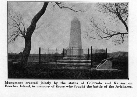
Monument erected jointly by the states of Colorado and Kansas on
Beecher Island, in memory of those who fought the battle of the Arickaree
Beecher Island
On my arrival, approaching from the south, the first sight in the distance which greeted my eyes was the monument. It was erected jointly by the states of Colorado and Kansas, at a cost of five thousand dollars. It is of light Barre, Vermont, and Colorado granite, and is eighteen feet high. Lieutenant Fred H. Beecher, U. S. Infantry, Surgeon J. H. Mooers and Scouts Louis Farley and William Wilson were killed in the battle and are buried on the Island. The following description taken from the monument tells the story:
North Side
“Battle of Beecher Island, fought September seventeenth, eighteenth and nineteenth, 1868, between Colonel George A. Forsythe’s company of citizen scouts, numbering fifty-one men, and a large party of Indians, comprising Northern Cheyennes, Ogallalah, Brule, Sioux and Dog Soldiers, commanded by the noted chief, Roman Nose. The scouts were surrounded and held on this island for nine days, subsisting on horse and mule meat. Indians killed, seventy-five, wounded, unknown. Here Roman Nose and Medicine Man fought their last battle.
South Side
“The first night Stillwell and Trudeau, crawling out on their hands and knees, started for relief, and hiding days and traveling nights they reached Fort Wallace. The third night Donovan and Pliley started. Arriving at the Fort, Donovan with four other immediately started back, and coming upon Colonel Carpenter’s command, on the south fork of the Republican, guided them in a twenty-mile dash. They reached the island at ten in the morning, the ninth day, and twenty-six hours in advance of Colonel Bankhead with Scouts Stillwell and Trudeau. The return to Fort Wallace was begun September twenty-seventh, the wounded being carried in government wagons.”
West Side
Sacred to the memory of those who fought and died here.
Foot Note: Lieutenant Fred H. Beecher was a nephew of the divine Henry Ward Beecher.
261
                             Killed


Lieutenant Fred H. Beecher, U. S. A.            W. Wilson

J. H. Mooers, Surgeon, U. S. A.                 L. Farley

                            G. W. Culver


                            Wounded


Colonel George A. Forsythe, U. S. A.         W. Armstrong

G. B. Clark                                   T. K. Davis

H. Davenport                                       B. Day

H. L. Farley                                     R. Gantt

J Haley                                     F. Harrington

L. A. McLoughlin                             W. H. McCall

H. Morton                                   T. O. Donnell

H. H. Tucker                                    F. Vilott


                          Uninjured

T. Alderdice                                     M. Burke

J. Donovan                                       G. Oakes

A. J. Eustler                                    W. Reily

A. Dupont                                      T. Ranahan

J. Hurst                                         C. Smith

A. T. Grover                              J. S. Stillwell

G. Green                                    S. Shlesinger

J. Lyden                                       E. Simpson

M. R. Lane                                     W. Steward

J. Lane                                         J. Thayer

M. R. Mapes                                    P. Trudeau

T. Murphy                                   C. B. Whitney

H. T. McGrath                                   W. Wilson

C. B. Nichols                                  E. Ziegler

C. C. Platt                                  A. J. Pliley
East Side
To ever keep green in memory those who fought here, this monument was erected by the states of Colorado and Kansas, A. D. 1905.
The monument is enclosed by an iron picket fence six feet high.
To commemorate this struggle between savage and civilized man, an association was organized for the purpose of holding annual celebrations on this ground. Temporary buildings have been erected for shelter in case of storm, and restaurant and refreshment stands were established for the accommodation of the public. The former scouts who were still
262
alive at this time and whose addresses were known were invited to the coming celebration. Some of them were living then in remote parts of the United States. They are now scattered from Washington, D. C., to the states of Washington and Oregon on the Pacific coast, and from New Mexico and Arizona in the south to Idaho in the north. A number have died since the battle and the addresses of others could not be found at this time but a number of the old scouts came back here and held a reunion.
An annual reunion of scouts and old settlers was held here in 1905 and 1906, and in the years following thousands of people have gathered here each year for this reunion. During the war these festivities were discontinued and now the buildings are in a somewhat neglected condition and need repairs.
Being satisfied by having seen this historic ground, I now took my departure, going by auto seventeen miles north to the town of Wray, located on the main line of the C. B. and Q. Railway, one hundred and sixty miles east of Denver, on the north fork of the Republican river. This is another enterprising city of several thousand inhabitants. With up-to-date public and private buildings, and other modern improvements.
All through this part of the country, from St. Francis to Beecher Island and the town of Wray, all along the line in Western Kansas and Eastern Colorado, the people are far more prosperous and the improvements far better than I expected to see.
The next and last battle field, Summit Springs, that I had planned to visit I thought was located sixty-five miles north of Wray, near Julesburg, in the extreme corner of the state of Colorado, near the Platte river.
Another automobile ride over a prosperous prairie country brought me to Julesburg, coming by the way of the town of Holyoke, on another line of the Burlington Railway, which runs from east to west into Denver.
I arrived in Julesburg in the evening. After getting a room at a hotel I at once looked up several old settlers and made inquiry as to the location of Summit Springs, and the distance to it, but to my surprise, I could obtain no information whatever; no one knew where the battlefield of Summit Springs was located.
In the battle the band of Indians was nearly annihilated
263
as the band on Sappa creek had been. I did not expect to find a monument to mark this battle field, but I thought it was so well known that on my arrival at Julesburg nearly anyone in the town could tell me where it was located.
The next morning I went to the printing office where a weekly newspaper is published. As a rule, publishers are familiar with all sorts of matters, but the office man in charge could do no better than refer me to some old-timers living in town, who might be able to give me the desired information, I looked up and consulted several of these persons without success.
I will here say, before the advent of the railroad old Julesburg and a government post, Fort Sedgwick, were located less than a mile apart on the south side of the Platte river, seven miles west of the present town of Julesburg, which at one time was called Denver Junction, here the Denver line of the Union Pacific Railroad branches off from the main line going to the Pacific coast.
Hercules H. Price, who had taken part in this fight, in one of his letters, gave me a description of the battle and made a diagram of the ground and the surrounding hills. This diagram he had sent to me. It showed a small valley with a large spring where these renegade Indians had their camp. According to the description, the locality was not far from Fort Sedgwick, where the troops marched the next day, and rested after the fight. But the description did not state the direction whether east or west. On leaving home, I had given no thought to this matter, as I thought almost anyone in Julesburg would be able to direct me to the place I wanted to see.
After consulting without success several of the oldest ranchmen who had retired from active work and were living in town, I was directed to Mr. Charles Morgan, a wealthy ranchman living in town, who owned the ranch which included a part of the old military reservation and the site of old Fort Sedgwick. He was familiar with the surrounding country and I thought that he might be able to assist me. I went to his house and found him at home, and also found him to be a very generous and obliging gentleman, ready to help me if possible. My inquiry and what I said was news to him. He had not heard anything of the battle, although he knew much historic matter about old Julesburg and Fort Sedgwick. He thought
264
he might be able to help me as he knew of several large springs up in the hills, one of these he believed might be the one I was looking for. He generously offered to take me in his automobile to those springs, an offer which I gladly accepted. The next morning three of us, Mr. Morgan and another man, a neighbor, and myself started on this investigating trip. We drove west on the north side of the Platte, seven miles, then crossing the river on a bridge, we came to his ranch.
Here I will diverge a little from the main topic to set forth some interesting historic information Mr. Morgan gave us. While we were viewing the old landmarks, Mr. Morgan told us that in the time of the existance of the fort there was no bridge, but there was a ferryboat which was used when necessary. I understood that ordinarily the river was crossed by teams, but there were certain times when high water made this impossible. A ferryboat was constructed, but there was no power to move the boat except hand power, not even a cable or guyrope to pull the boat, only men with poles to push, the current being relied no to do most of the work. In consequence, the boat always floated some distance down stream before reaching the opposite or north bank.
On the return trip the boat again floated quite a ways down stream until it recahed the south bank, a considerable distance from the original starting point. In order to bring the boat back to its place a string of ox-teams and a tow line were used to pull it up the river.
This ferryboat, once so useful to the pioneers, now lies on the edge of the river, covered with sand by the ever shifting current of the water. Parts of it may yet be seen protruding from beneath the sand, a relic of bygone days.
Of Fort Sedgwick there were yet a few remnants of the old ruins left to be seen, and Mr. Morgan was able to show us where the barracks and other buildings stood in the time of its usefulness. I took particular notice of the hospital site, because Mrs. Weichel, a Kansas woman, was treated and nursed back to health after being held captive by this band of Indians, and on the appearance of the troops in the beginning, of the battle she was shot by the chief. Her companion, a Mrs. Alderdice, was killed by the same chief and buried on the battlefield.
265
Mr. Morgan also showed us several other interesting landmarks. There were ditches on the outside of the fort which no doubt had been dug for protection, as the garrison here was often small, and the Indians were generally here in force, and were quite troublesome at times. Many raids were committed by them on the overland stage line and isolated ranches. One of the most disastrous and effective raids made by the savages was the one in which they sacked and burned Julesburg in the year 1865, almost with rifle shot of the fort.
Mr. Morgan seemed to be well informed in regard to the history of these old landmarks. He told us of several incidents which happened prior to his coming here which he learned from old residents, and also some of his own experiences. He said Julesburg was named after a Frenchman named Jules, other authorities say he was a French-Canadian trapper named Jules Bernard. At any rate he was commonly known as “Jules.” He was a squaw man, having an Indian squaw for a wife.
He had a store on the south side of the Platte River in close proximity to Fort Sedgwick, and traded with the Indians. In those days all stores kept whisky for sale, and there were often drunken rows among the stage drivers and frontiersmen. At one time Jules got into a row with a drunken desperado named Slade, who kept the stage station at this point, and in the melee, with a sawed-off shotgun, filled him full of buckshot. Slade was taken to Denver and with good nursing got well and came back here. Later, Slade, with companions of like caliber, got the advantage of Jules, captured him and tied him to a tree. Slade shot off his fingers and toes and otherwise mutilated and finally killed him. He then cut off his ears and carried them about in his pockets, offering them for drinks in saloons, and he wore one of the ears as a watch charm. Slade eventually drifted into Montana, and in 1865 was hanged by a vigilantes committee on suspicion of being the leader of a band of road agents. When he was about to be hanged, a justice of peace interferred and admonished the men not to besmirch the name of Montana with a lynching but to give the culprit a trial. Accordingly a jury was drawn. It was said Slade had a fair trail. The jury was drawn as in civilized communities. He was tried and found guilty and immediately executed by hanging. This was said to have been the first legal execution in Montana.
266
“About the sixties,” Mr. Morgan said, “along the overland trail, came six Missourians from California past Fort Sedgwick on their way home to Missouri. They had with them six horses or mules heavily loaded. They were supposed to have been miners carrying with them the proceeds of their labor in gold dust or bullion. While at the post they were warned of the danger of hostile Indians in the vicinity. They were advised to camp at the Fort that night. But they did not heed the warning, and answered that they came all the way from California and had not been molested, and did not apprehend any danger. The passed the Fort in the evening and camped a short distance beyond. This was their last camping place, as the Indians made a raid on them and killed every one, capturing their pack horses and making away with them. The next day these unfortunate travelers were buried on a little knoll near their camping place, where they were killed. Years later, after Mr. Morgan came into possesion of this land, wishing to plow up this part of the prairie adjoining another field, he went before the county commissioners and asked them to have the bodies removed to the cemetery, as he did not wish to desecrate the graves of those unfortunate people. But Mr. Morgan was told the dead rested well where they were, and to go ahead and plow the ground, which he did. So the six Missourian travelers are resting under the field annually cultivated, and the location of the graves is known only by the knoll on which they lie buried. Mr. Morgan drove his automobile by this place, and pointing it out to us, said: “Whether those travelers had gold with them or not was never positively known. It never showed up at the trader where the Indians came to barter, and where plunder usually showed up after a successful raid.
After Mr. Morgan had shown us the historic places and told us what he knew about them, we proceeded on toward the hills, to see the springs. We drove into the hilly country and after spending a good part of the day driving the automobile many miles, seeing several springs without finding the place, we returned to the north side of the river, back to Julesburg. My inability to find this battlefield was the greatest surprise and disappointment I experienced on this trip.
The story of the battle is told in another chapter, and I will here only state that it was no small affair, to be easily forgotten. I will here quote from the book, “True Tales of the
267
Plains,” page 156, by General Carr: “After the battle a board of officers counted the dead Indians, notwithstanding that it is their custom to carry away the wounded and to hide or bury the dead. We found sixty-eight dead bodies on the field.”
Major North, commander of the Pawnee scouts of the expedition, in his report to the Nebraska Legislature, gives the number of dead Indians at fifty-two. The exact number of Indians killed probably was not known, as it was a running fight and lasted from the middle of the day until dark, chasing the fleeing Indians and killing them wherever the soldiers caught up with them, consequently, the dead bodies were scattered over a wide area of the hills and prairie. William Cody, “Buffalo Bill,” was with the expedition, in after years he made the Battle of Summit Springs a feature of his Wild West show, showing this scene all over the United States and Europe. How such an occurrence could be forgotten in the vicinity where it happened is a mystery to me.
I also interviewed an old ranchman named Andrew Walrath, who, still hale and hearty, was living a retired life in town. He in his younger days had acted as guide many times and had been instrumental in trailing Indians and recovering horses and other livestock from them, after they had been successful in raids. He, perhaps, had more experience than any other man now living in this section. In our conversation he told me of several of these experiences, among them the burning of his ranch, a short distance east of Julesburg, by Sioux Indians, in 1872. In meeting this man I felt certain of receiving the desired information, but he, too, had not heard of the Battle of Summit Springs.
Without being able to learn anything in this direction, I left Julesburg, very much disappointed, for the next station, ten miles west. There I made further inquiries, but failed to find anyone who could assist me in my investigation.
In trailing these renegade Indians, the days prior to the battle, the troops followed the Indians up Frenchman creek, and the battle ground therefore is located between the head of that creek and the Platte river in he direction of Sterling. I had not been cautious in figuring the direction in that way, as I confidentally expected to obtain this information as soon as I arrived at Julesburg.
Reluctantly, without accomplishing my purpose, I took
268
the train to Sterling, and went from there to Denver, and from there returned home to Lincoln, Kansas.
The following may serve as an explanation why this important event in our history had been forgotten. At the time the battle was fought the country was uninhabited; besides Fort Sedgwick there were only a few isolated ranches and stage stations. After the battle the troops marched to Fort Sedgwick, where they rested. From here the soldiers were transferred to other sections of the country. This vicinity remained uninhabited for sixteen years. Fights with the Indians had been so frequent that little attention was paid to any one in particular. The settlers who came here to make their home knew nothing about these affairs. Fort Sedgwick was abandoned by the government, the quarters were torn down and the whole improvements erased from the site, and the stirring events of those times in this locality were allowed to sink into oblivion.
ADDITION TO CHAPTER 32
Several years since writing the above, while on my way to Denver, I stopped at Sterling, Colorado, to make another attempt to find the Summit Springs battlefield. This time with more success, as I learned that these historic springs are located eighteen miles southeast of Sterling, many miles farther up the Platte river than I had been looking for the time previous.
In later years Nebraska parties became interested. In June, 1929, a historian, Mr. Clarence Reckmeyer of Fremont, Nebraska, together with Captain Luther North, now in his eighty-third year, who was then commander of a company of Pawnee scouts, and took part in the battle, visited this battlefield and located the places where the main events took place. Later I corresponded with Mr. Reckmeyer in regard to this matter. He was then making preparations to mark these places of importance. When I learned of this, I took the train for Colorado and met him near the battleground. He had with him a small map made by Captain Luther North, while I had a blue print of the one made by Mr. Price. Comparing these I concluded that the locations were as near correct as could be expected after these many years.
Mr. Reckmeyer had with him wood markers; attached to these were lettered copper plates giving a short description on each plate. There were set in cement, protruding about a foot
269
above ground. One was set about where Mrs. Alderdice was buried. The other two near the place at the Broken Canyon, where the Indian Chief Tall Bull was killed, and the position of Major Frank North when he shot him.
After all the effort I made to find these historic places, spending my time and paying expenses, I feel well paid and satisfied in having made the effort.
ADDITION TO CHAPTER 32
The Battle of Summit Springs as Told by Clarence Reckmeyer
of Fremont, Nebraska, Whom the Writer Met on the
Battlefield in September, 1929, Is Here Recited.
On June 6, 1929, I had the pleasure of going over the Summit Springs battlefield with Captain Luther H. North, who, with North’s Pawnee Scouts, took part in the battle of July 11, 1869. The site of the battle is located about twelve miles south and five miles east of Sterling, Colorado on Section one (1), Township five (5) North, Range fifty-two (52) West, on land belong to R. H. Bruce.
Among the Cheyenne Indians one of the most important organizations was the Dog Soldiers, of which Tall Bull was chief. The members were brave warriors. It was considered a great honor to belong to this band and a successful horse thief and murderer was entitled to membership. In the spring of 1869, Tall Bull, with about eighty-five lodges of Cheyennes and a number of Sioux, commenced raiding and murdering down in Kansas. There were perhaps a thousand Indians in the band. On May 30th they attacked a Danish settlement in what is now LIncoln County, Kansas. Here a number of settlers were killed and Mr. G. Weichel and Mrs. Suzannah Alderdice were taken prisoners. Eli Ziegler, brother to Mrs. Alderdice, and Thomas Alderdice, her husband, had taken part in the Beecher Island fight the year before. Mrs. Alderdice was allowed to keep her baby for a few days, but its crying so annoyed the Indians that they finally killed it.
In June, 1869, General Eugene A. Carr, with eight companies of the Fifth Cavalry, under Majors Royall and Crittenden and one hundred Pawnee Indian Scouts, under Captain Luther H. North, left Fort McPherson, Nebraska, for the Republican River Valley in southwestern Nebraska. William F. Cody accompanied the expedition as scout for the Fifth Cavalry. Cody never had any connection with the Pawnee Scouts and they were never subject to his orders.
When they arrived at a point near the mouth of Prairie Dog creek, in what is now Harlan County, Nebraska, they were met by Major Frank North and a company of fifty more Pawnee Scouts, who had come by way of Fort Kearney. Scouting westerly up the Republican valley they struck the trail of the Cheyennes and after a number of interesting skirmishes they reached the Beecher Island Battlefield, Colorado, on July
271
9th. About this time they observed the imprint of a woman’s shoe on the trail, which was their first intimation that Tall Bull had white women captives. Major Frank North’s diary for this day reads as follows:
“In camp on Beecher Battleground--arrived here at four P. M. Marched thirty-three miles without water and, oh, how hot and dry. The wounded man is doing fine. We have very poor water. Nothing but standing rain water. One antelope today.” Major North’s diary is the best record of the march:
“Saturday, July 10, 1869. This morning moved at six A. M. and marched thirty-five miles, passed three of the Indian camps. Water poor. In the morn’ we move early and take three days’ rations on pack mules and light out for the Indians. We will have a fight tomorrow sure.
On the next day, July 11th, the Indian trail divided into three. General Carr with part of his men and about a half dozen Pawnees took the left hand trail to the northwest. Major Royall with all the rest of the white soldiers, except those who were coming along in the rear with the wagon train, William F. Cody, and a number of the Pawnees, took the right hand trail to the northeast. The North brothers, Captain Cushing and about forty Pawnees, took the middle trail straight north. Again I quote Major North’s diary:
“Sunday, July 11, 1869. Marched this morn’ at six A. M. with fifty of my men and two hundred whites, with three days’ rations. Follow trail until three P. M. and came up to
![]()
The North Brothers
![]()
![]()
![]()
 |