CHAPTER 1.
THE TRAILS OF THE EXPLORERS.
Part 1
EARLY FRENCH AND SPANISH EXPLORERS - WHEN FATHER MARQUETTE CAME - FATHER HENNEPIN'S WONDERFUL MAP - EXPLORATIONS OF LEWIS AND CLARK - FIRST FOURTH OF JULY CELEBRATION IN KANSAS - CAPTAIN PIKE'S EXPEDITION - MAJOR LONG'S EXPEDITION - FRENCHMEN OUR FIRST MERCHANTS - THE FUR TRADERS - THE GREAT AMERICAN DESERT - THE FREMONT EXPEDITIONS - SCENES OF RARE BEAUTY - PHYSICAL AND GEOGRAPHICAL FEATURES, ETC.
The annals of the state of Kansas and of the county of Wyandotte, reaching far back into the shadowy realms of romance and tradition, are so closely entwined that to write of the one also is to write of the other. Kansas, a mighty republic of itself, stretching from the Missouri river almost to the foot hills of the Rocky mountains, takes its name from the dominant tribe of North American Indians first found dwelling here; while Wyandotte, the Gateway or Open Door to that great empire, borrowed its name from the tribe of Indians that brought civilization to the region lying west of the Missouri river. Linked to these two is a history of development, of progress, of achievement, as romantic as any that ever has been told in song or story; for no other community in America has been brought up from a desert plain and made to blossom as a rose in so short a period of time.
Through the long years of colonial times when this nation was young, even to the beginning of the first half of the century that preceded this one, the land that now is embraced in the state of Kansas was a field of exploration and adventure. When the white people came to make their homes here they found this country checkered over with the trails of these bands of explorers and adventurers; and-as the railroads now meet at the place where the Kansas river joins the Missouri river to flow down to the sea - so these old trails, the marks of which have not been entirely obliterated in the years that have passed, generally started from this point and struck out across the plains to the west, the southwest and the northwest.
Barring the expedition in 1541 of that Spanish grandee, Corona, who came up from New Spain, or Mexico, to search for the fair land of Quivira and its fabled cities of gold, it might well be recorded that the landscape of Wyandotte county was the first in Kansas to be looked upon by the eye of a white man, and its soil the first to receive the impression of the foot of a white man. Coronado did not come this way, else he might have told a different story. He crossed Kansas going from the southwest to the northwest, reaching the Missouri river near the site of the city of Atchison. There he gave up the search, caused a cross to be erected out of a pile of stones bearing the inscription
"Thus Far Came Francisco de Coronado,"
"General of an Expedition."
and returned to New Spain, sick, sore and disgusted. He did not come to Wyandotte county, and the record he left behind was of no practical value to the generations upon generations that were to follow him.
When visited by Coronado in 1541, the Pawnees were undoubtedly controlling the country drained by the Kansas river and its numerous affluents, certainly as far east as Topeka, while the Kansas Indians were dwelling along the Missouri. At the time of Governor Onate's visitation, sixty years later, the advance guard of the Pawnees seem to have progressed northward as far as the Platte river, though they had not actually taken final possession of any considerable area, as the greater portion of them seem to have fondly lingered in Kansas, apparently reluctant to part entirely from the pleasant conditions there once enjoyed. Between the coming of Governor Onate (1601) and the massacre of Villazar with his command (1720) upon the Platte river, a few miles east of the junction of the north and south forks of that stream, the Pawnees had taken full possession of all the desirable land within the valley of the state, except a small district adjacent to the Missouri, which the small tribes of the Otoes (Otontanta), Omahas (Mahas) and Poncas, who had contended, or at least unsuccessfully disputed, the suzerainty of the Pawnees over the domain. The point in the distant south whence the Pawnees first begun their remote northern migration is indicated by the Paniassa village, near the northern margin of Red river.
It is a question not altogether free from doubt as to who was the first to come up the Missouri river to explore the country that now is Kansas; yet it is the opinion of many of the most trustworthy authorities that the first one was Father Jacques Marquette, the Jesuit missionary and explorer. In 1673, two years after the founding of the mission at St. Ignace, Father Marquette and Louis Joliet, with the sanction and active aid of Talon, the intendant of Canada, and under direct orders from Louis de Baude, Conte de Frontenac, governor general of Canada under Louis XIV, were sent on a long contemplated exploration of the country west of the great lakes. That was the most important of all of the expeditions of the good Father Marquette. In birch bark canoes the expedition proceeded across the head of Lake Michigan, passed through Green bay, thence up the Fox river, and crossed the portage to the Wisconsin river, down which they floated into the Mississippi river. Frontenac had written to his king that he would in all probability prove once for all that the great river flowed into the Gulf of California. He, no doubt, was disappointed with his disillusionment when Father Marquette reported that his expedition floated down the Father of Waters far enough to be convinced that it must empty into the Gulf of Mexico and not into the Pacific ocean. What disappointment Father Marquette may have experienced is of little consequence in this article. He promptly transferred all hopes of that nature to the Missouri river on the theory that the Western ocean could be reached by ascending the Missouri. When Marquette saw the Missouri river debouching with such terrific force into the placid Mississippi he was struck with awe, for it was at the time of the June flood. The Indians among whom he went to establish missions for their conversion know little geography beyond their own hunting grounds. Those who dwelt along the Mississippi or Missouri rivers knew not whence these streams came nor whither they went. He inquired of the natives through his interpreter about this wonderful stream, which white men had not seen before. The natives informed him, os he recorded in his journal, that: "By ascending this river for four or five days one reaches a fine prairie, twenty or thirty leagues long. This must be crossed in a northwesterly direction, and it terminates at another small river, on which one may embark. This second river flows toward the southwest for ten or fifteen leagues, after which it enters a lake, which flows toward the west, when it falls into the sea. I have hardly any doubt it is the Vermillion Sea." That was the name of the Gulf of California in Father Marquette's day.
Just how far Father Marquette's expedition ascended the Missouri river above its mouth is a matter of speculation. Certainly it is that he came as far up as one hundred miles and the Indians among whom he mixed freely told him that which was of great value concerning the beautiful country bordering on the Missouri and Kansas rivers and their numerous tributaries. And the maps and records he left behind are now carefully preserved in the great library at St. Mary's College in Montreal.
It is noticeable that, though the Arkansas Indians dwelt upon the river of the same name, and were thoroughly conversant with its general direction, the location of the villages of their tribe upon it, as well as the general character of the country upon either side, Indian-like they made no disclosures relative to either of these topics, while concerning districts more remote they were ever ready to speak precisely and fully. The explanation of this attitude was that they were not yet fully satisfied as to the precise purpose of the two strangers in coming thither, and so for the time they simply refrained from imparting further information.
This map, crude though it may be, serves to present with surpassing accuracy the domain now constituting the states of Arkansas, Missouri, Kansas and Nebraska, together with the designation and location of the several tribes then (1673) known to be occupying territory within the northern and southern limits as marked by Marquette. The unoccupied country in the central region may naturally have been a common and convenient hunting ground for the various tribes.
La Salle, who was the first to discover the mouth of the Mississippi river, where he planted the flag of France, the standard which still waved over the land when Jefferson purchased the country of Napoleon, also was disappointed. Like Father Marquette, he transferred his hopes to the Missouri river. He "conceived the hope of reaching the South Sea by the Missouri river."
Father Gabriel Mausest wrote a letter from Kaskaskia in 1712, which displays the prevailing misconception as to geographical matters. He wrote: "We are but thirty leagues from the mouth of the Missouri or Pek-i-tan-oni river. This is a large river which flows in to the Mississippi, and they pretend to say that it comes from a still greater distance than that river. It comes from the northwest very near where the Spaniards have their mines in Mexico, and it is very convenient for the French to travel in this country."
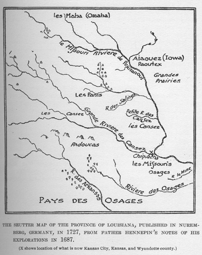
THE SEUTTER MAP OF THE PROVINCE OF LOUISIANA, PUBLISHED IN NUREMBERG,
GERMANY, IN 1727,
FROM FATHER HENNEPIN'S NOTES OF HIS EXPLORATIONS IN 1687.
It was Father Hennepin, a Franciscan missionary, who explored the country in 1687, fourteen years after Father Marquette, and acquired the wonderful knowledge of the west that resulted in the making in 1723 of a map that could lay claim to any degree of authenticity. This wonderful map made from Father Hennepin's notes was by that German geographer, Matthew Seutter, and his co-laborer, John Baptist Hamann, both of Nuremburg, Germany, in those days the center of the world's mapmaking industry. The Seutter map of Louisiana was made before St. Louis was founded and before there were any towns along the Mississippi river. The rivers are laid down with remarkable accuracy and practically all of them large and small, are shown. The Indian villages are indicated by groups of dwellings. The Kansas river appears on the maps as "Grand Riviere Causez. The Chicago river is "Chigogon."
Several Frenchmen came up the Missouri river in the eighteenth century on exploration expeditions and made trips through Kansas, but there was nothing done to change the existing conditions. The Indians were not disturbed, the soil was not stirred by the plow, the rich valleys brought forth no harvest other than the luxuriant vegetation of nature's planting. It was only when the United States government, under the leadership of Thomas Jefferson, became the owner of the vast area that had been shifted back and forth between France and Spain that systematic effort began to be made to find out its real extent and possibilities for future development.
President Jefferson himself had but a vague conception of the purchase he had made, but he was keen to know, and for that reason encouraged and urged the fitting out of an expedition to explore the country, if possible, to the Pacific coast. This expedition, led by those two brave captains, Meriwether Lewis and William Clark, was one of the most marvelous journeys ever undertaken or accomplished by man. It was different from the explorations conducted by the Spanish and French adventurers in that Lewis and Clark made careful note of everything they saw, and were able on their return to give a comprehensive and intelligent description of the vast region they had traversed between St. Louis, the starting point, and the Pacific ocean. On the 14th day of May, in the year 1804, the Lewis and Clark expedition set out from St. Louis. For nearly seven weeks the explorers pursued their slow and toilsome way across what is now the great state of Missouri. On June 26th the expedition camped on the bank of that river, near the mouth of the Kansas river near what is now known as the old Wyandotte levee. Here we have the meeting point of these two rivers described in the Lewis and Clark journals:
"June 26, 1804. - We encamped at the upper point of the mouth of the river Kansas. Here we remained two days, during which we made the necessary observations, recruited the party and repaired the boat. The Kansas river takes its rise in the plains between the Arkansas and Platte rivers and pursues a course generally east till its junction with the Missouri, which is in latitude 38 degrees, thirty-one minutes, and 13 seconds. Here it is 340 1/4 yards wide. though it is wider a short distance above the mouth. The Missouri itself is about 500 yards in width. The point of union is low and subject to inundations for 250 yards. It then rises a little above high water and continues so as far back as the hills or highlands which come within one mile and a half of the river. On the north of the Missouri river they do not approach nearer than several miles, but on all sides the country is fine. The comparative specific gravities of the two rivers is for the Missouri 78 and for the Kansas 72 degrees. The waters of the latter have a very, disagreeable taste. The former has risen during yesterday and to-day about two feet. On the banks of the Kansas reside the Indians of the same name. On the 29th we set out late in the afternoon and having passed a sandbar, near which the boat was almost lost, and a large island on the north, we encamped at seven and a quarter miles on the same side in the lowlands where the rushes are so thick that it is troublesome to walk through them. Early the next morning, 30th, we reached at five miles distance the mouth of a river coming from the north and called by the French Pettit Riviere Platt, or Little Shallow river. It is about sixty yards wide at its mouth."
Leaving the beautiful hills in what is now Wyandotte county behind the bold explorers proceeded on the journey up the Missouri river. On the morning of the 4th of July, 1804, at the mouth of a little stream which empties into the Missouri river, near where the city of Atchison now stands, the Stars and Stripes were flung out upon the breeze, a swivel gun boomed out its note of sovereignty and trimuph and the first Fourth of July Celebration was held on Kansas soil. All day long the little band rested and celebrated, no doubt contemplating what the future had in store for this fair land. As the sun was sinking low in the west the gun boomed again and the soil of Kansas was dedicated to freedom and the republic. Here is what is recorded in the Lewis and Clark journals for that glorious day: "The morning of the 4th was announced by the discharge of our gun. At one mile we reached the mouth of a bayeau or creek coming from a large lake on the north side of which appears as if it had once been the bed of the river, to which it runs parallel for several miles. The water of it is clear and supplied by a small creek and several springs, and a number of goslings which we saw on it, induced us to call it the Gosling lake. It is about three-fourths of a mile wide, and seven or eight miles long. One of our men was bitten by a snake, but a poultice of bark and gun powder was sufficient to cure the wound. At ten and one-fourth miles we reached a creek on the south about twelve yards wide and coming from an extensive prairie, which approached the borders of the river. To this creek, which had no name, we gave that of Fourth of July creek. Above it is a high mound, where three Indian paths center, and from which is a very extensive prospect. After fifteen miles sail we came to, on the north a little above, a creek on the southern side, about thirty yards wide, which we called Independence creek, in honor of the day, which we could celebrate only by an evening gun, and an additional whiskey to the men."
Two years after Lewis and Clark had gone on to blaze a way across the plains and mountains, another gallant captain, leading twenty-two stalwart, fearless white men and some fifty Indian allies, started on another tramp across the plains. Among all the American soldiers who have dared to endure privations and dangers at the command of their country, many have commanded larger armies, and some have wrought greater things, but no one is better entitled than Captain Zebulon Montgomery Pike to place in history or to the encomiums of his own and succeeding generations. With a determination that overcame every difficulty, and a spirit that quailed at no danger, he pushed on across the prairies until he had reached the snow-capped Rockies and scaled the peak which stands as an everlasting monument to perpetuate his name. In what is now the county of Republic, in Kansas, he found at the Pawnee village the Indian had not learned that there had been a transfer of authority. The Spanish flag was still floating above the camp. A less intrepid man than Pike would have passed by with his twenty-two men, but such an action was not in keeping with the bold and loyal nature of the young captain. Without a moment's hesitation he ordered the emblem of Spanish authority to be hauled down, and, elevating the Stars and Stripes in its stead, he proclaimed the sovereignty of the republic.
The Pike expedition was to promote peace and friendship among the people of the plains. He was told to take the captive Osages in the cantonment of Missouri back to their tribe; then he was told by General Wilkinson to turn his attention to bringing about a perfect peace between the Kansas and Osage Indians, and lastly to effect a meeting and establish a good understanding between the Iatans and the Comanches. His instructions read:
"Should you succeed in this attempt, and no pains must be spared to effect it, you will endeavor to make peace between that distant powerful nation and the nations which inhabit the country between us and them, particularly the Osage; and, finally, you will endeavor to induce eight or ten of their distinguished chiefs to make a visit to the seat of government next September, and you may attach to this deputation four or five Panis and the same number of Kansas chiefs. A, your interview with the Comanches will probably lead you to the head branches of the Arkansas and Red rivers, you may find yourself approximated to the settlements of New Mexico, and there it will be necessary you should move with great circumspection, to keep clear of any hunting or reconnoitering parties from that province, and to prevent alarm or offense; because the affairs of Spain and the United States appear to be on the point of amicable adjustment; and, moreover, it is the desire of the president to cultivate the friendship and harmonious intercourse of all the nations of the earth, and particularly our near neighbors the Spaniards."
The story is familiar to all, of Pike's arrival, September 25th, at the Pawnee village, and the call for a grand council on the 29th. On that day the flag of Spain floated before the chieftain's tent. Standing here on the plains, a little handful of men, far away from their own kinsman, faced 400 men of alien blood. Pike, armed with a sublime faith in God and his western mission, demands that the flag of Spain be taken down. It is a dramatic moment. He says every face was full of sorrow. The plain, unassuming band of Americans made but a tame impression on these children of the prairies, beside the memory of the gay chevaliers of Spain so recently departed; but the might of the spirit prevailed.
The manhood of Pike and his men struck a spark from the manhood of the Indians, and an old man took the flag of Spain and meekly laid it at his feet. In its place he ran up the American flag, the symbol of our national life. The Indians put their faith in the strength and righteousness of men who came to them for the sake of brotherhood, rather than in the material grandeur and military display of Spain. And to-day there are a million and a half of people dwelling in harmony and plenty in the shadow of this sublime beginning.
Following in the wake of Pike went Major Stephen H. Long and other explorers, giving to Jefferson and other leading statesmen of that period some idea of the magnificent extent and possibilities of the empire that had been acquired for what would now be considered a paltry sum, a financial burden which could now be easily assumed by the least wealthy of all the states in this Union.
![]()
Transcribed from History of Wyandotte County Kansas and its people ed. and comp. by Perl W. Morgan. Chicago, The Lewis publishing company, 1911. 2 v. front., illus., plates, ports., fold. map. 28 cm. [Vol. 2 contains biographical data. Paged continuously.]
