
Barber County Kansas

|
Barber County Kansas |
|
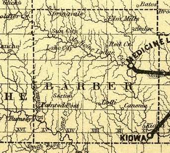
1886 map of Barber County, Kansas, showing Elm Mills.
The Kansas Gazeteer & Business Directory For 1888-1889 Elm Mills . In Barber county, 15 miles northwest of Medicine Lodge, the county seat and bank location, and 4 1/2 miles from Sawyer, on the AT&SF RR, the nearst railway pont. Stages daily to Medicine Lodge and Sawyer. Population, 45. D.M. Stewart, postmaster.
Brown, C.R. - miller
Johnson, A.J. - flour mill
Jones, S.S. - live stock
Light, Samuel - live stock
Sparks, A.G. - live stock
Sparks, C.C. - live stock
Sparks, Wm. H. - live stock
Stewart, A.D. - live stock
Stewart, C.J. - grocer and live stock
Stewart, W.C. - grocer
Tramne, Louis - live stock
Wilson, A.S. - live stock(Contributed by Kim Fowles).
The Elm Mills Post Office was established 21 Nov 1878 and discontinued 15 Sept 1893. -- Source: Post Offices in Kansas, 1828 - 1961, The Kansas State Historical Society.
(Note the discrepancy in the above dates of operation for the post office.)
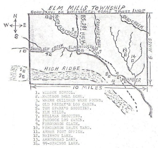
Elm Mills Township, Barber County, Kansas.
Map drawn by George Miller.
Courtesy of Kim Fowles.
"I have a small "booklet" titled "Some Elm Mills History Copied by George Miller from Barber County Historical Files of Library at Medicine Lodge." It outlines several things that happened in the Elm Mills Township; one of which was the Hillman matter. This map was a page in that stapled booklet. Apparently Mr. Miller (of Sawyer, KS) drew this diagram and plotted the happenings on it.There was also a copy of an article from the Pratt Tribune dated 2/4/1969 talking about the history compiled by George Miller of Sawyer. So, I am guessing he did this prior to 1969."
- Email from Kim Fowles to Jerry Ferrin, 7 March 2006.
Map of Elm Mills Township courtesy of Kimberly (Hoagland) Fowles. Two copies of this map appear on this page; an overview and a LARGE version.
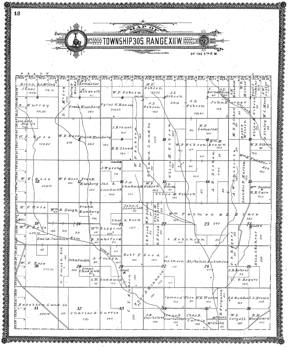
Use your horizontal & vertical scroll bars to view the large version of the map.Elm Mills Township 30S. Range XIIW of the 6th P.M.,
G.A. Ogle Map, Barber County, Kansas
Land Owners Identified on this Map:
A. Asheroft, J. Brower, S.S. Brown, Wm. M. Brown, H.H. Case, C.W. Chadwick, Isaac Chadwick, J.D. Chadwick (?), Jas. R. Chadwick, John A. Chadwick (?), A. W. Chilcote, Col. & U.S. Mty. Co. (?), W. L. Coryell, Chas. B. Currie, Wm. B. Daigh, M.E. Dicken (?), A. B. Dioken (?), H. Ferguson, D. Finley, Olive M. Gibson, S.I Gibson, W.P. Gibson, Chas. R. Good, Robt. F. Good, J. Harper, John Harper, Hazelton Land Co., O.K. or O.H. Herndon, Perry G. Hicks, C.T. Hudson, David Jackson, Paul S. Jenkins, Alvan Jones, Thos. B. Kinkaid, Frank Kumberg, D. Lansford, N.F. Lomaster (?), Leondis B. Martin (?), D.S. McCoy, McCully, W.D. Miller, W.C. Moore, R. Murray, Ottawa Land Co., Isaac B. Overholser, J.B. Overholser (?), W. H. Painter Estate, Wm. Palmer, Cyrus N. Reeves, Wm. Riggins, Alphonso Robinson, E.D. Roddie, Ella C. Roher, S.B. Roher, U.G. Rogers, W.F. Rose, G.W. Saller (?), John Smith, L. Smith, H.H. Steed, W.H. Warren, Robt. E. Wilson, James A. Wise, R.M. Woodward, S. Wysong.
Also see: Map of the Hillman Shooting.
Thanks to Kimberly (Hoagland) Fowles for finding and scanning this map for this web site!
The Killing of George Castine by David Stewart at Elm Mills
-- articles collected by Kim Fowles.Truman Churchill Civil War veteran
|
|

|
