

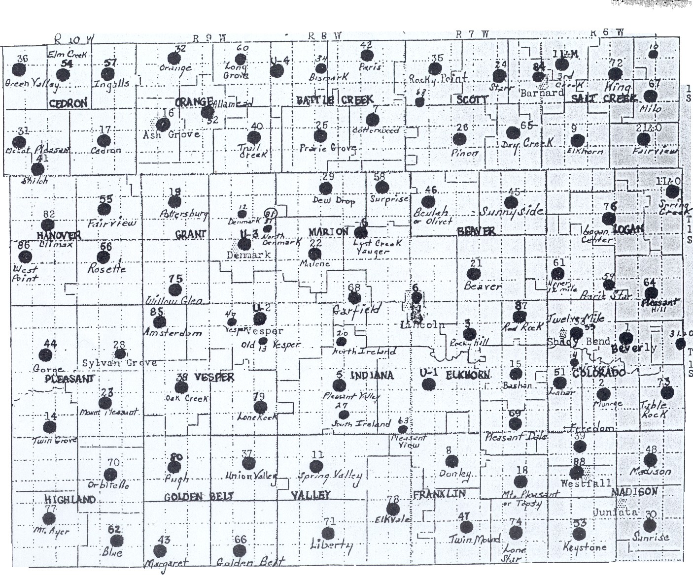
Lincoln County Kansas School Districts
Lincoln County School Districts
(Township indicates the township in which the school itself was located, in
order to help in using the map. Many school boundaries went across township
lines.)
1. Beverly (Colorado)
2. Monroe (Colorado
3. Rocky Hill (Elkhorn)
4. Fairview (1893-1912) (Colorado)
5. Pleasant Valley (Indiana)
6. Lincoln (Elkhorn)
7. Cottonwood (Battle Creek)
8. Donley (Franklin)
9. Elkhorn (Salt Creek)
11. Spring Valley (Spring Valley)
12. Denmark (1893-1917) (Grant)
13. Old Vesper (1893-1914) (Vesper)
14. Twin Grove (Pleasant)
15. Bashan (Elkhorn)
16. Ash Grove (Orange)
17. Cedron (Cedron)
18. Mt. Pleasant/Topsy (Franklin)
19. Pottersburg (Grant)
20. North Ireland (1893-1917) (Indiana)
21. Beaver (Beaver)
22. Malone (Marion)
23. Mount Pleasant (Pleasant)
24. Star (Scott)
25. Prairie Grove (Battle Creek)
26. Pinon (Scott)
27. South Ireland (1893-1914) (Indiana)
28. Sylvan Grove (Pleasant)
29. Dew Drop (Marion)
30. Sunrise (Madison)
31. Mount Pleasant (Cedron)
32. Orange (Orange)
33. Twelve Mile (Shady Bend) (Colorado)
34. Bismark (Battle Creek)
35. Rocky Point (Scott)
36. Green Valley (Cedron)
37. Union Valley (Golden Belt)
38. Oak Creek (Vesper)
39. Freedom (Madison)
40. Trail Creek (Orange)
41. Shiloh (Cedron)
42. Paris (Battle Creek)
43. Margaret (Golden Belt)
44. Gorge (Pleasant)
45. Sunnyside (Beaver)
46. Beulah or Olivet (Beaver)
47. Twin Mound (Franklin)
48. Madison (Madison)
49. Old Vesper (1891-1914) (Vesper)
51. LaBar (Owl Creek) (Colorado)
52. Allamead (Orange)
53. Keystone (Madison)
54. Elm Creek (Cedron)
55. Fairview (Hanover)
56. Rosette (Hanover)
57. Ingalls (Cedron)
58. Surprise (Marion)
59. Prairie Star (1893-1921) (Logan)
60. Long Grove (1893-1920) (Orange)
61. Upper Twelve Mile (Logan)
62. Blue (Highland)
63. Pleasant View (1893-1912) (Indiana)
64. Pleasant Hill (Logan)
65. Dry Creek (Scott)
66. Golden Belt (Golden Belt)
67. Milo (also #10) (Salt Creek)
68. Garfield (Marion)
69. Pleasant Dale (Elkhorn)
70. Orbitello (Highland)
71. Liberty (Valley)
72. King (Salt Creek)
73. Tablerock (Colorado)
74. Lone Star (Franklin)
75. Willow Glen (Grant)
76. Logan Center (Logan)
77. Mount Ayer (Highland)
78. Elkvale (Valley)
79. Lone Rock (Vesper)
80. Pugh (Golden Belt)
81. North Denmark (1894-1917) (Grant)
82. Climax (Hanover)
84. Barnard (Scott)
85. Amsterdam (Vesper)
86. West Point (Hanover)
87. Red Rock (Elkhorn)
88. Westfall (Madison)
U1 (Elkhorn), U2 (Vesper), U3 (Grant) and U4 (Battle Creek) mark the sites
of unified districts.
1 L & E (Lincoln and Ellsworth counties) -- Yordy (1896-1926) (Not on the map)
1 L & M (Lincoln and Mitchell counties) -- 3rd Creek (1893-1932)
1 L & O (Lincoln and Ottawa counties) -- Spring Creek (1893-1932)
2 L & O (Lincoln and Ottawa counties) -- Fairview (1893-1947)
3 L & O (Lincoln and Ottawa counties) -- Rocky Hill-County Line (1893-1927)
Return to Education in Lincoln County Kansas main page.Return to Lincoln County Kansas Genealogy main page.
DO YOU HAVE
QUESTIONS, COMMENTS, CONTRIBUTIONS FOR US?

Bill and Diana Sowers
, Lincoln County Coordinators
Tracee Hamilton, Lincoln County Coordinator
| Search all of Blue Skyways
Copyright 1997, 1998 by Bill and Diana Sowers
| 