Geology.—Kansas is a part of the Great Plains area stretching from the Mississippi river on the east to the Rocky mountains on the west, and from Mexico on the south to Canada on the north. The 37th parallel north latitude constitutes the southern boundary and the 40th parallel the northern; the eastern boundary is approximately 94 degrees 40 minutes west from Greenwich, and the western boundary is a few miles beyond the 102d meridian, making the state approximately 207 miles north and south, and 405 miles east and west, containing about 82,500 square miles. Kansas, therefore, is an important and essential part of the Great Plains area and does not differ very materially from other portions of the same great area lying on all sides of it.
In general, the surface of the entire state slopes from the west towards the east, with an elevation on the west varying from 3,500 to 4,000 feet above sea level, while on the eastern boundary the elevation varies from about 730 to 1,025 feet. The drainage of the state, therefore, is from west towards the east. The largest stream in the state, the Kansas river, flows approximately straight east the entire length of the state. Here and there at various places surface levels in a north and south direction vary sufficiently to modify the local drainage. This is particularly true in the northwest corner of the state where various tributaries of the Republican river flow northeast, and all the way along the southern boundary where the streams flow to the southeast. The lowest place in the state is claimed by two points, one at Kansas City, the mouth of the Kansas river, and one near Coffeyville where the Verdigris river crosses the southern boundary, each with an elevation of approximately 700 feet above sea level. The general physiographic conditions of the state, therefore, are quite regular and when properly interpreted will throw light on the physiography of the entire plains. However, the otherwise monotonously smooth surface area hundreds of miles in extent has been relieved by nature carving relatively deep channels for her numerous streams, with broad rolling prairie uplands on the divides, which also are frequently varied by the presence here and there of individual mounds, and long stretches of steep escarpments sometimes hundreds of feet in height. Profound lithologic variations have necessitated these varying results of erosion, so that instead of a landscape tiresome in its regularity and lack of individuality usually attributed to the Great Plains of Kansas by the uninformed, one finds in reality a surface with ever changing details and unusually pleasing effects.
The geologic structure of Kansas, when considered on a grand scale, is simple, but in detail often becomes complex and difficult. In the extreme southeastern part of the state, covering an area not exceeding 30 square miles in extent, dense limestones and interbedded chert rocks of Mississippian age occupy the surface. They are the oldest rocks in the state and constitute a floor upon which succeeding formations repose.
Immediately above the Mississippian limestones and cherts lie the Coal Measures sandstones, limestones and shales, occupying a zone of about 20,000 square miles across the entire east end of the state. They reach an average thickness of 3,000 feet, with a maximum, perhaps, close to 4,000 feet.
Above and immediately overlying the Coal Measures, we find the Permian occupying a wedge shaped area about 35 miles wide on the north, covering the western part of Marshall county, and the eastern part of Washington county, and fully 185 miles wide on the south side of the state, reaching from the east side of Cowley county westward to the east side of Meade county. The uppermost part of the Permian, and hence the western part, is composed of red colored clay shales and imperfect sandstones usually designated as the Red-Beds.
The Permian rocks are immediately overlaid by the Cretaceous. Along the southern boundary we find a small fringe of Comanchic Cretaceous just above the Red Beds throughout Clark, Comanche and Barber counties. Apparently the Red Beds disappear northward, although the salt mines at Ellsworth pass through what seems to be their northern extension. If so, quite possibly the Comanche likewise extends that far north, although at present there is no positive information on this subject.
Above the Comanche in turn we find the Dakota Cretaceous occupying an area trending northeast and southwest almost entirely across the state and varying from 10 miles wide on the north to a total of 100 miles wide east and west in the central part of the state where the river channels have cut through the overlying formation and exposed the Dakota the maximum distance to the west. The Dakota in turn is overlaid by the Benton occupying a zone trending southeast and northwest approximately parallel with the Dakota area just mentioned and a little greater in extent. Above the Benton is the Niobrara, followed by the Ft. Pierre, and possibly a little of the Fox Hill in the extreme northwest corner of the state.
The western end of the state is covered with a mantle of soil, sand and gravel, generally considered Tertiary in age, which has been carried eastward by river action from the Rocky mountain region. It is spread out like a veneering which perhaps never quite reaches 300 feet in thickness in Kansas. Drainage channels are cut through it in places, exposing the underlying Cretaceous rocks, so that a correct geological map would represent the western extension of the Cretaceous formations following up the several drainage streams in long slender necks towards the west, with the Tertiary veneering on top extending eastward in long tongues, occupying the high divides between the streams.
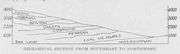
GEOLOGICAL SECTION FROM SOUTHEAST TO NORTHWEST.
For convenient reference a diagramatic vertical geological section across the state from southeast to northwest is here given, and also a general geological column to represent the relative position of the Kansas section. It will be seen that our oldest rocks occupy the later Paleozoic, that the Triassic and Jurassic are absent in Kansas, so also are all the lower Cretaceous up to the Comanche, and that the Fox Hill and Laramie of the Upper Cretaceous are also wanting. For a good lithographic map showing the surface outcroppings of all Kansas formations the reader is referred to Volume IX of the Geological Survey of Kansas.
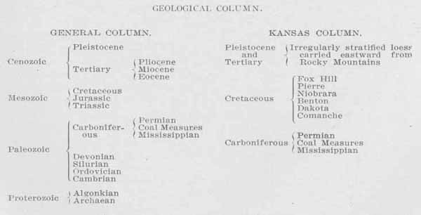
GEOLOGICAL COLUMN.
Having given a general review of the geology of Kansas in the preceding paragraphs, it is now in order to take up the several subjects and treat them more in detail.

DETAILED KANSAS GEOLOGICAL SECTION.
The Mississippian rocks occupy a surface area of about 30 square miles in the extreme southeast part of the state. It is triangular in outline, about 6 miles wide on the south and 10 miles wide on the east. Spring river almost determines the western boundary of the area, but here and there erosion has worn away the overlying Coal Measures, exposing the underlying Mississippian in patches of irregular outline a few miles farther west. Beyond the limits of Kansas the Mississippian formations extend eastward, southeastward and northeastward over a large part of Missouri, northeast Oklahoma, northwest Arkansas and stretches away beyond the limits of Missouri into Iowa, Illinois, Kentucky and Tennessee. They are from 200 to 300 feet in thickness, and have been drilled through in many places, such as Pittsbnrg, Girard, Columbus, Galena, Iola, Neodesha, Stone City, Caney. They rest immediately upon Silurian rocks, where exposed at the surface in Missouri and Arkansas and presumably also in Kansas.
The Mississippian rocks essentially are limestones, but here and there thin clay and shale partings are found, by drilling, although in general such partings are insignificant and unimportant. Throughout the limestone, also, are masses of flint rock, or chert, exceedingly variable in extent and outline. In the vicinity of Galena such chert masses are miles in surface extent and hundreds of feet in thickness. Eastward in Missouri they are very large and abundant. A peculiarly great interest attaches to them because they are the principal bearers of lead and zinc ores throughout the entire Joplin area, which is the greatest zinc producing area in the world.
The entire Mississippian limestone formation passes westward to an unknown distance, dipping about 25 feet to the mile along the south line of the state from Galena to Caney, which is the westernmost point at which its presence positively has been identified. In a north direction the dip of the surface is much less, reaching only about 4 1/2 feet to the mile for the entire distance from Galena to Kansas City. Many hundreds of oil and gas wells have been drilled through the overlying Coal Measures, so that the upper surface of the Mississippian throughout the oil and gas fields in the southeastern part of the state has been very well located. It is also interesting to know that flint bodies occur irregularly throughout the area explored by deep wells the same as farther east where the rocks are exposed to the surface. Numerous wells in the oil and gas fields went down into the Mississippian to variable distances, and some of them entirely through it. In some instances large quantities of flint have been found by the drill, and in others none at all, precisely as would be the case were one to drill throughout the area where they are exposed to the surface.
Eastward from the limits of Kansas the Mississippian limestones gradually rise to Springfield, and beyond, covering a large catchment area. Here rainwater finds its way between the rock layers and slowly works its way down the bedding plain slope westward and appears again in large quantities in the mines throughout the zinc mining area, and also farther west in deep wells where it is used for municipal supplies in such towns as Pittsburg, Weir City, Girard, Cherokee, Columbus, and a number of other smaller places.
Economic Products.—The Mississippian rocks carry values of great commercial importance of three distinct characters. 1st, Building stone and lime; 2nd, water; 3d, ores of lead and zinc.
1. Building Stone and Lime: The Mississippian limestones are usually solid and compact, and in many places are completely crystalline. These properties, added to a high degree of chemical purity, make an unusually valuable building stone which is almost white in color, and hence attractive for costly buildings. Extensive quarries are operated in the same rock masses in nearby localities near Carthage, Mo., from which vast quantities are shipped in many directions to be used in high grade buildings. Also, the same limestone around Ash Grove, Mo., is burned into a superior white lime which is shipped all over Kansas, Missouri, Oklahoma and elsewhere. Equally good building stone and lime may be had from the Mississippian rocks in Kansas and are now lying there awaiting the activity of operators.
2. Water: As already explained, the Mississippian formation extends east and occupies the surface throughout the highlands of south central Missouri around Springfield where a copious rainfall supplies an abundance of water, portions of which become lodged between the rock layers and gradually work down the dip plains westward. In this way large quantities of water are obtained by deep drilling in many places in southeastern Kansas, and different municipalities obtain a satisfactory supply of good water in this manner.
3. Ores of Lead and Zinc: By far the most important product obtained from the Mississippian formations in southeastern Kansas and southwestern Missouri are the ores of lead and zinc which occur here in such large quantities. The principal ore of lead is galena, a sulphide of lead (PbS), although small amounts of the carbonate and sulphate are found, named cerussite and anglesite respectively. The principal zinc ore is sphalerite, or zinc blende, also a sulphide (ZnS), often called "jack" locally, zinc carbonate Smithsonite, and zinc silicate calamine occur sparingly. The productive area in Kansas has a much smaller acreage than is found across the state line in Missouri, but no richer lead and zinc mines have ever been developed in the world than in some portions of Kansas. One piece belonging to the South Side Mining and Smelting company, containing only 80 acres, has already produced ore with a market value of more than $4,000,000, with scarcely a shaft as much as 200 feet deep. The entire yield from Kansas has reached as high as $2,000,000 a year in ore values, which would be more than $3,000,000 if the value of the metal were counted.
How long these rich mines will continue to be profitable no one can foretell, but when we consider that the mining thus far is all in shallow ground, and that elsewhere as great or greater values continue downwards for 1,000 feet or more, it seems probable that this area also will be productive for many scores of years yet to come.
Stratigraphy.—The Coal Measures of Kansas occupy about 20,000 square miles in the eastern end of the state. They immediately overlie the Mississippian, and in turn are overlaid by the Permian. The eastern limit of their area is the line trending northeast and southwest previously described as the western limit of the Mississippian. Along this boundary the Coal Measure rocks are very thin. Their base plane dips gently westward about 25 feet to the mile on the south line, while the surface gradually rises, so that the Coal Measures formation constitutes a wedge pointing eastward.
The lowermost formation of the Coal Measures is a shale bed, somewhat variable in thickness in different parts of the state, but which averages about 450 feet. These have been called the Cherokee shales, on account of their extensive surface exposure in Cherokee county. Immediately above the Cherokee shales are two limestone formations separated by 7 to 8 feet of black shale which together are called the Fort Scott limestone. These in turn are overlaid by 40 feet of shale known as the Labette shales, followed by 22 feet of the Pawnee limestone, above which are alternating beds of limestones and shales, the latter often carrying large bodies of sandstone, from the bottom to the top of the Coal Measures. Each of these individual limestone and shale beds has been studied in detail by the Kansas Geological Survey, has been named and the line of outcroppings of all the principal formations traced on the various maps in Volume IX of the State Geological Survey, to which the reader, if interested, is referred for a detailed discussion. These several individual horizons have been grouped together into stages named as follows, beginning at the base: Cherokee, Marmaton, Pottawatomie, Douglas, Shawnee and Wabaunsee. The scheme at the end of this article illustrates these details and generalities better than can be described in ordinary sentences.
All of these several formations overlie each other in regular order, as shown in the above mentioned scheme. In every instance each individual formation outcrops to the east and lies buried to the west beneath the overlying formations. Throughout the entire Coal Measures area from top to bottom, the strata dip westward, while the surface is inclined to the east. Traveling westward, therefore, one is constantly passing from the lower formations to the higher, or from the older to the younger. A drill hole put down to the west, consequently, will pass through the succeeding formations downward in regular order.
Beyond the limits of Kansas the Coal Measures extend east and north into Missouri and Nebraska and from there northeast into Iowa, making the Kansas coal fields continuous stratigraphically with the coal fields of Missouri and Iowa. On the south they extend far into Oklahoma, from which place they veer eastward and constitute the coal fields of Arkansas. The Kansas coal fields, therefore, lie midway between those of Arkansas and Oklahoma on the south, and Missouri and Iowa on the north.
Economic Products.—Kansas Coal Measures are noted for being rich in five particular kinds of products, namely: 1. Coal; 2. Oil and Gas; 3. Clays-Shales; 4. Cement material; and 5. Building Stone.
1. Coal: About the middle of the Cherokee shales three distinct beds of coal are found and are mined very extensively, particularly in Cherokee and Crawford counties, while coal seams occupying the same stratigraphic levels are known to exist in many other places in the state, particularly in the vicinity of Kansas City, Leavenworth and Atchison. In some places but one of these veins seems to have been developed to a considerable extent, while elsewhere all three of them are of commercial importance. At present (1911) more than 90 per cent. of all the coal being mined in the state is obtained from the Cherokee shales.
Well up in the Marmaton stage is another bed of coal known to be extensively developed in the vicinity of Pleasanton and La Cygne, and probably future prospecting will find the seam in many more places. This is usually known as the Pleasanton coal and has been mined in many places in the valley lying between Pleasanton and La Cygne, and for miles to the east. No one knows the size of this coal area, but probably it is much more extensive than is known at present.
Other lesser beds of coal are found irregularly here and there throughout the Pottawatomie stage, but none of considerable importance as we pass upwards until the Douglas stage is reached. Here, from 50 to 100 feet below the Oread limestone, a bed of coal occurs irregularly entirely across the state. It is developed in the bluffs along the Missouri river near Atchison, lying about 100 feet below the Oread limestone, where it was mined to a considerable extent in time past. Southward, in Douglas county, in early days of Kansas history, it was mined at probably fifty different places. Still further southward, in Franklin county, it was mined in many places around Pomona, Ransomville and Williamshurg. From here to the southwest a line of early day mines can he traced entirely across the state, where local mines were operated in the winter season for wagon trade.
Passing up the geological column to near the top of the Shawnee stage another vein of coal is found marking a line here and there entirely across the state from northeast to southwest. The coal here is confined principally to the Severy Scranton shales, with the mines most abundant all the way from a few miles west and southwest of Topeka, to the vicinity of Osage City, where mining is still prosecuted on a commercial scale.
2. Oil and Gas: Almost all the oil and gas thus far developed in Kansas has been obtained from the Cherokee and Marmaton stages, with more than nine-tenths of it coming from the Cherokee shales. The principal productive fields, of course, lie to the west of the outcropping areas, so that wells are drilled from 500 to 1,600 feet in depth before reaching the productive zones. Oil and gas are found almost universally in sandstone, probably because the pores serve as receptacles for them, and these sandstones lie interbedded in the Cherokee shales and some of the shales higher up the geologic column. Farther to the west in the vicinity of Elmdale, Augusta and Arkansas City small developments of gas have been made in wells of varying depth where the Permian rocks are exposed at the surface. In all cases probably the drill went entirely through the Permian and into some of the upper Coal Measure formations, but by no means deep enough to reach the formations which produce oil and gas in such large quantities farther east.
3. Clay-Shales The Coal Measure shales, in general, are excellent clays for making a great variety of brick, tile and other clay products. The clay industry to date has been developed principally in the southeastern part of the state where fuel is abundant and cheap, either in the coal fields of Cherokee and Crawford counties, or in the gas fields a little farther west. Shales belonging to different stratigraphic horizons have been used in different places and have been found to be exceedingly valuable for making all kinds of street-paving brick, common building brick, dry-pressed, fancy red brick, side-walk brick, hollow clay building tile, drainage and sewer tile. At Pittsburg and vicinity the Cherokee shales have produced a desirable material for this purpose. At Coffeyville the Coffeyville shales produce excellent brick. About Cherryvale the Cherryvale shales are equally desirable, and so on almost to the top of the Coal Measures formations, with practically all the intervening shales producing very satisfactory material, as is witnessed by the high quality of brick produced from the Chanute shales at Chaunte, the Lane shales at Table Mound west of Independence, the Lawrence shales at Lawrence, the Calhoun shales at Topeka, etc.
4. Cement Material: The limestone of the Coal Measures formations of Kansas, while in general not absolutely pure, is excellent material for the production of Portland cement, when properly mixed with Coal Measure shales. Fortunately, the impurities present in the Iimestone are identical with the materials of the shales, and therefore are in no way objectionable. The shales also, interbedded with the limestones, seldom contain any impurities which are detrimental to the manufacture of high-grade Portland cement. This fact in connection with the abundance of fuel coal, natural gas, and fuel oil, has resulted in the erection of numerous Portland cement plants in the southeastern part of the state, each of which draws its raw materials from the Coal Measures limestones and shales. It is fortunate that such valuable materials exist in such large quantities because the Portland cement industry has now become one of the leading manufacturing industries of the state and the supply of material is sufficiently abundant to last literally millions of years.
5. Building Stone: Many of the limestone horizons in the Kansas Coal Measures produce excellent building stone and the broad prairies are dotted here and there with scores of stone quarries, some of which already have reached a considerable magnitude of production. The sandstone beds here and there interbedded with the shales likewise produce good flagging stones for making walks and for other constructional purposes. Should the time ever come when a larger amount of highgrade building stone is required, either limestone or sandstone, the Coal Measures of Kansas may be called upon to increase the present production many hundred fold.
Stratigraphy.—The Permian formations of Kansas are composed almost entirely of alternating beds of limestone and shales with much less sandstone in the shale than is found below in the Coal Measures. The Permian rocks overlie the Coal Measures conformably; that is, their bedding planes are approximately parallel with the bedding planes of the Coal Measures. In general physical and chemical properties also, the Coal Measures rocks grade into Permian so that the only definite criterion for separating them is the character of the animal and plant life as represented by the fossils found in them. The line of demarcation between the west limit of the Coal Measures and the eastern limit of the Permian is an irregular one trending, in general, north and south from near the northeast corner of Marshall county to the southeast corner of Cowley county. On the high ridges the Permian extends farther east, because it overlies the Coal Measures, while in the valleys, such as the Kansas river valley, erosion has worn away the overlying Permian exposing the underlying Coal Measures much farther to the west. In this way the line of demarcation is more or less tortuous, varying in extreme cases as much as 35 miles in an east and west direction.
Naturally, the Permian is divided into two great divisions, the lower and the upper, the lower Permian being composed of light colored limestones and light or dark green colored shales, while the upper Permian is composed of red colored shales and imperfect sandstones, commonly known as the Red-Beds. All the Permian formations dip gently to the west, so that here, the same as with the Coal Measures, one traveling westward is continuously passing from the lower to the higher strata from the older to the younger. Drill holes put down at any point at the western limit of the Permian, therefore, will penetrate the several subdivisions in succession, and should they be carried far enough, would penetrate the Coal Measures likewise, which underlie the Permian.
In a north and south line the rock strata are continuous and almost level, so that the outcropping of any one formation may be traced north and south entirely across the state. It appears that the Permian is much less in thickness at the north than at the south. All the upper Permian here is wanting, so that the overlying Dakota Cretaceous rests immediately on the Permian, while in the south, the thick red-beds intervene between the lower Permian and the Cretaceous. Beyond the limits of Kansas, the Permian extends both north and south. On the north it reaches only about 30 miles into Nebraska until it becomes entirely covered by the Dakota Cretaceous which laps eastward and rests on the Coal Measures formations. From the south side of the state it extends southward through Oklahoma and Texas.
Economic Products.—The Permian of Kansas is particularly noted for its large quantities of salt, but, in addition, it also supplies unlimited quantities of clay-shale and building stone.
1. Salt: Kansas has enough salt, sodium chloride (NaCl), to supply the world for many thousands of years. It is regularly interbedded with the Permian shales. The eastern limit of the salt beds is a few miles west of Wichita, McPherson and Salina, while the western limit has not been determined, neither has the northern nor the southern limits. At Hutchinson the salt is known to he 415 feet thick. Northward it appears gradually to grow thinner and is about 200 feet thick at Kanapolis and Ellsworth, and 10 feet thick at Lincoln, where a deep well drilled early in 1911 proved its presence and quality. At Kingman and Hutchison it is about 600 feet below the surface, at Lyons 800 feet below the surface and at Ellsworth and Kanapolis 600 feet. A deep well at Anthony also showed an abundance of salt. From here southward it extends far across into Oklahoma.
Salt is mined by two distinct processes. Rock salt is obtained by sinking a shaft to the salt and mining it much as coal is mined. It is then hand sorted, crushed and passed over sieves of different grades and sent into the market in desirable forms. The other grade of salt is obtained by first drilling a hole, like an oil well hole, down to the rock salt and inserting a pipe which fits lightly into the well and extends down to the top of the salt. A smaller pipe is now put inside the first one and carried down to the bottom of the well. A pump is then attached to the larger, or outside, pipe and water is forced down into the well. In time it dissolves all the salt it can dissolve, about one pound of salt to 36 pounds of water, and is forced up through the inner pipe. A new well furnishes but little brine, because the surface area is so small it requires so long a time for the water to become saturated. But as solution continues the surface becomes larger, so that within a year or so the pump can he kept running constantly and a good strong brine is constantly delivered by the smaller pipe. The brine is then evaporated by artificial heat and "evaporated" salt is obtained.
2. Gypsum: Gypsum is the foundation for one of the great industries of Kansas. Rock gypsum is found in many places in the Permian. Extensive factories are now in operation in the vicinity of Blue Rapids, in Marshall county, in southern Dickinson county, and in Barber county, all of which use rock gypsum. A few years ago a number of plants were operating on gypsum or on gypsite, beds of which are found here and there throughout the Permian area. Rock gypsum occurs in a well stratified form interbedded with other Permian formations. About Blue Rapids and Hope it lies beneath the surface, but in Barber county, and stretching away southward into Oklahoma, it caps the hills similar to the way limestone does so frequently throughout the Coal Measures area. It occurs in a well stratified form, can he quarried the same as stone and is sufficiently pure to meet all the requirements for the manufacture of high-grade plaster and other goods made from gypsum. Gypsum is used for making different grades of hard wall plaster. In its present form it is a hydrated calcium sulphate (CaSO4 + 2H2O). When ground to powder and heated it gives up a portion of the water of crystallization and takes on a property by which it may again absorb water and harden, or "set." Different grades of plaster are made by driving off different proportions of water. Also by certain secret treatments a superior grade is made known as Keen's cement, which is used extensively for interior decorations of costly buildings.
3. Clay-Shale: But little development work has been done on the clay-shales of the Permian. It is known, however, that many of them will prove exceedingly valuable. Chemical analysis shows that they contain less iron than the Coal Measure shales to the east, and, therefore, it may reasonably be expected that a great variety of light colored brick and terracotta may be made from them. A rich harvest awaits the development of the Permian clay industry.
4. Building Stone: The Permian affords some of the best building stone in the state, principally limestone. Here and there throughout the entire area from the north side of the state to the south good building stone is available.
According to the general geological section previously given the great Cretaceous complex is divided first into the lower and upper, and the upper again subdived[sic] into a number of individual stages and formations. For a proper study of Kansas Cretaceous, one should begin at the bottom of the Cretaceous column, which would carry him far to the south beyond the limits of the state to the vicinity, we will say, of El Paso. It seems that the great mid-continental sea which existed to the west of the Coal Measures and Permian areas of Kansas had more favorable conditions for the production of thick heavy beds southward than to the northward throughout the earlier part of Cretaceous time, and further, that a gradual uprising to the south drove the ocean waters northward into the Arctic Ocean where they now are. In this way a great midcontinental area was covered thousands of feet in depth with Cretaceous rocks, the lower and older ones towards the south and the younger and upper ones towards the north.
Comanche: In Clark, Comanche, Kiowa and Barber counties we find a small mass of Comanche Cretaceous which is the uppermost subdivision of the Lower Cretaceous. This is wedge-shaped, tapering northward and thickening to the south in Oklahoma and Texas. It disappears under the Tertiary south of the Arkansas river and thus far no tracings of it have been found north of the counties named. Probably it underlies the Tertiary for some distance north of where it is now observable, but where its true northern limit is can only be determined by proper explorations beneath the surface of the Tertiary in the area south of Great Bend.
Dakota: The lowermost member of the Cretaceous found in considerable quantities in Kansas is the Dakota. It has a large development in an area reaching northeast and southwest from Washington county to Edwards county, as already described in previous pages, with traces of it here and there in the southwest part of the state where the Cimarron and Bear rivers have cut through the Tertiary, veneering and exposed long narrow strips of Dakota rocks. Probably it underlies the entire southwest corner of Kansas including six or eight counties south of the Arkansas river, throughout which the Tertiary mantle obscures it from sight.
The Dakota rocks lie almost horizontally, but throughout their westernmost exposure dip gently to the east. For example, their elevation in Morton county is over 3,500 feet above tide, while their easternmost outcrop in the central part of the state is below 2,000 feet. This is in conformity with what one should expect when it is recalled that the same Dakota formation outcrops throughout a long zigzag area along the eastern foothills of the Rocky mountains, where they have a north and south extent of thousands of miles at an altitude of from 5,000 to 7,000 feet above tide. This easterly dip throughout eastern Colorado and western Kansas is common not only to the Dakota strata, but to all the rocks overlying them, due evidently to the uplifting of the Rocky mountains, by which process the old interior ocean was drained northward as above explained.
The Dakota Cretaceous consists of alternating beds of sandstone and shales aggregating a thickness of about 450 feet. Usually the sandstone is coarse and porous and has many springs bursting out along the eastern outcropping lines, the source of the water of which, of course, is the catchment area westward along the mountainous borders. The eastward migration of water throughout these many hundreds of miles is well proven from the various artesian wells available here and there over the Great Plains area. It seems strange to many that these springs should be on or near the hill-tops and on the high ground rather than in the valleys, where springs generally occur. When it is remembered, however, that the present eastern demarcation of the Dakota is largely controlled by erosion, and how, therefore, the easternmost limits necessarily will be on the high divides between the stream, one can readily understand how water traveling from the west towards the east finally will find outlets along the eastern border of the sandstone, and therefore, on the high ground. Another natural sequence follows from the conditions just named, namely, that these seeps and springs carrying traces of iron leached from the rocks will have the same iron deposited in the sandstones where the seeps are evaporated, so that, in general, the eastern limits of the Dakota sandstones have a reddish or dark iron-stained appearance, often refered to by local residents and generally explained by assuming that at some previous time the rocks have been burned to give them their peculiar colors.
The Dakota sandstone, therefore, in general is a coarse rock exceedingly pervious to water, colored yellow, reddish and brownish by iron rust stains, and suitable in every way for carrying large quantities of water, which is one of its most striking characteristics. Also, the Dakota shale beds of Kansas are particularly noted for the large amount of salt they contain. One result is, that the siliferous shale beds have been eroded away more rapidly than the rocks below and many peculiarly shaped depressions result, the most noted of which is the so-called "basin" just north of Great Bend. Here the siliferous shales have been washed away and a circular "fry-pan" shaped basin formed. Northward, in many places salt marshes exist, such as the famous one near Concordia. These marshes become more or less filled with water throughout the winter and spring, which leaches large quantities of salt from the siliferous shales. During the dry weather of summer and early autumn the water becomes evaporated, leaving a variable amount of salt behind. In early days of occupation of the plains by white men, such salt marshes were visited by people for hundreds of miles around, the salt scooped up from the ground and hauled away by wagon loads. Recently, since our salt mines have been in operation in the central part of the state, no further attention is given the salt marshes in an industrial way.
1. Clays. The clays of the Dakota are numerous and variable in quality and bid fair to become some of the most valuable in the state, on account of their great variety. In places they are almost free from iron, producing a clay approaching fire-clay in quality, which is very suitable for making light colored and buff colored brick and ornamental terracotta.
Benton.—Immediately overlying the Dakota, and conformable with it, we find the Benton complex of limestones and shales, aggregating a thickness of about 400 feet. It is composed almost entirely of alternating beds of soft, light colored limestone and darkly colored, sometimes almost greenish shales, which in other places are practically black. The limestones are in broad thin layers much softer than the Coal Measures limestones, but substantially the same in chemical composition. They lend themselves readily to quarry purposes and may be broken readily into long slender pieces suitable for fence-posts, for which they are used to a great extent throughout the entire Benton area of the state. In fact, one riding east or west across the state on any of the trans-state railroads north of the Arkansas river can recognize when he is in the Benton area by the limestone fence-posts so readily seen from the car window. This fence-post zone is from 30 to 40 miles wide and practically outlines the area throughout which the Benton formation covers the surface of the ground. The stone is so soft it can be cut with a carpenter's saw and shaped at pleasure. Upon exposure to the atmosphere it dries and hardens so that it becomes quite servicable for structural poses, and many pretentious buildings are built of it.
The Benton shales thus far have been used but little in the economic arts, although, as shown from preliminary examinations, they are servicable for making many kinds of brick, tile, and other clay products. Also, they are servicable for making Portland cement when properly mixed with calcareous material, as is shown by the plant at Yocemento in Ellis county, which uses the uppermost horizon of Benton shales mixed with the overlying Niobrara chalk for making Portland cement.
Niobrara.—Overlying the Benton and conformable with it we find the Niobrara shales and limestones, aggregating about 500 feet in thickness. The limestones are the famous Kansas chalk. The eastern limit of the Niobrara, which is also the western limit of the Benton, is an exceedingly irregular line stretching from the middle of the north side of Washington county southwestward, crossing the west side of the state about 8 or 10 miles north of the Arkansas river. Much of the area to the west is covered with Tertiary material, so that the exposure of Niobrara is confined principally to the valleys and bluffs of streams, although there is no doubt about it being a continuous formation underneath the Tertiary.
This general outcropping border corresponds with the ideas advanced in speaking of the northward recession of the great inland sea, the extreme southwest corner of the state being occupied by the Dakota, then a strip of Benton along the Arkansas river, and now the Niobrara on top of the Benton as one travels westward and northward. On a geological map of Kansas one would find, therefore, comparatively small areas occupied by the Niobrara, but, could one by magic remove the Tertiary mantle, without doubt the Niobrara would occupy as large an area, probably much larger, than either the Benton or the Dakota.
The Niobrara limestone, or chalk, is distinguished from the Benton in physical properties principally by its thick, heavy beds rather than thin well-marked ones common to the Benton, and by the general chalky nature of the material. In chemical composition it is about as pure a limestone as is found in the state, ranging from 90 to 96 per cent, pure lime carbonate. It is particularly soft, so that it may be whittled with a knife or cut with a saw almost like shale. Here and there ground water has deposited silica within it, producing locally masses of agate and other silicious forms of rocks, some of which are of the moss-agate variety and fairly beautiful. The upper Niobrara, also, is noted for its abundance of fossils, reptiles and fishes which are found here and there wherever the Niobrara is exposed throughout the state.
Pierre.—In the extreme northwest part of the state some of the streams have cut through the mantle of Tertiary exposing Cretaceous rocks which usually are considered to belong to the Pierre, or Ft. Pierre, as it was previously called. Some parties have also thought that the Fox Hill was exposed in the vicinity of St. Francis, Cheyenne county, although usually this is considered Pierre. Both the Pierre and Fox Hill occur in much greater abundance farther to the north and northwest. How much of either of them underlies the Tertiary in Kansas probably never will be known, but so small an amount of each of them is actually found that their importance is correspondingly reduced.
Tertiary and Pleistocene.—As already explained, the western end of Kansas is covered by a veneering or mantle of material carried eastward by rivers from the great Rocky mountain area. This debris, or löess as it is now frequently called, covers the entire plains area from the foothills of the Rocky mountains eastward far into the Dakotas, Nebraska, Kansas, Oklahoma and Texas. It consists principally of soil, sand and gravel, which in places seems to be reasonably well stratified, but which in general is practically void of structure. Here and there are coarse gravel beds extending miles horizontally and from 5 to 100 feet vertically, the sand and gravel of which is cemented together by calcium carbonate, forming a sandstone of variable hardness which has been called by different names, such as "mortar beds," 'Tertiary grit," etc. This Tertiary mantle carries the vast amount of ground water found so abundantly throughout the plains area. Also, here and there it carries many fossils of vertebrae animals, important to the paleontologist. It seems that in geological age, the oldest of it is at least as old as the Loup Fork Tertiary, while recent winds and river action has worked over the surface material until part of it, at least, and probably much of it, should be designated as Pleistocene. In general, it has quite the appearance of river alluvium and, broadly speaking, is about as regular in character as alluvium usually is, while in detail it differs very materially from place to place, again very much like river alluvium.
Pages 721-746 from volume I of Kansas: a cyclopedia of state history, embracing events, institutions, industries, counties, cities, towns, prominent persons, etc. ... / with a supplementary volume devoted to selected personal history and reminiscence. Standard Pub. Co. Chicago : 1912. 3 v. in 4. : front., ill., ports.; 28 cm. Vols. I-II edited by Frank W. Blackmar. Transcribed May 2002 by Carolyn Ward.
![]()
TITLE PAGE / LIST OF ILLUSTRATIONS
INTRODUCTION
A | B | C | D | E | F | G | H | I
VOLUME II
TITLE PAGE / LIST OF ILLUSTRATIONS
J | K | L | Mc | M | N | O | P | Q | R | S | T | U | V | W | X | Y | Z
VOLUME III
BIOGRAPHICAL INDEXES
