Oregon Trail.—The Oregon Trail, which started from Independence, Mo., entered Kansas near the mouth of the Kansas river and ran in a general westerly direction to the Pacific coast, the approximate distance being about 2,124. The early history of the trail dates back to the time of the Astorian expeditions of 1811-1813. In 1823 or 1824 Gen. W. H. Ashley traversed the trail, discovering a more suitable way through the Rocky mountains by way of South Pass. Jedidiah S. Smith in 1826; Capt. Benjamin L. E. Bonneville and party in 1832, and Nathaniel J. Wyatt the same year, were among the first to leave written accounts of having traveled over this historic thoroughfare. The trail was undoubtedly a well-established Indian highway long before its use by the trappers, hunters and early explorers. As early as 1840 it came into general use, and during the next seven years approximately 12,000 persons destined for Oregon passed over it. From 1840 until the advent of the railroad, it was practically the only way to reach those remote localities unless going by water. During the Mormon hegira and the subsequent emigration to California, thousands of emigrants left the Missouri river for the far west, though no correct figures are obtainable of the extent of the passenger and freight traffic passing over the trail. That part of the trail between Independence and Grand Island on the Platte river was in use at an early day, but no record of when or by whom it was opened can be found.
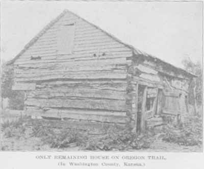
ONLY REMAINING HOUSE ON OREGON TRAIL.
(In Washington County, Kansas.)
Fort Leavenworth, St. Joseph, Mo., and Council Bluffs, Iowa, figured some as outfitting points for emigrants during the latter days of the trail, and the road from the first two points intersected the Independence road in what is now Marshall county, Kan., but the bulk of freight and travel went by way of Independence, from which point the trail entered Kansas in Sec. 22, T. 12, R. 25 E., and traversed the counties of Johnson, Douglas, Shawnee, Pottawatomie, Marshall and Washington, leaving the state in Sec. 6, T. 1, R. 5, near the 97th meridian. In its early days the following were the noted points along the line, in what is now Kansas, and their distances from Independence: Elm Grove, Round Grove, or Caravan Grove, variously called, 33 miles; Junction of Oregon and Santa Fe trails, 41; Wakarusa creek, 53; Kansas river, 81; Turkey creek, 95; Little Vermillion, 119; Big Vermillion, 160; Big Blue, 174; Nebraska line, about 200 miles.
The route in detail through Kansas, as taken from the original surveys now on file in the office of state auditor at Topeka, was about as follows: Entering Kansas in Johnson county it passed along the Santa Fe trail through what is Olathe, and on to the junction of the Oregon and Santa Fe trails located a little south of west of the present town of Gardner; thence continuing in a northerly direction towards the Kansas river, it entered Douglas county in Sec. 27, T. 13, R. 21 E.; thence to the west a little south of the present town of Eudora; thence in a northwesterly direction through the old town of Franklin to the site of the present city of Lawrence; thence via Marshall and Big Springs, entering Shawnee county in Sec. 15, T. 12, R. 17 E.; thence up the south side of the Kansas river, passing the village of Tecumseh, to the Kansas river at Papan's ferry, now in the heart of Topeka, where it crossed to the north side of the river, continuing west about midway between Soldier creek and the river, near the modern villages of Menoken, Silver Lake and Kingville and on to Rossville, crossing old Turkey (now Cross) creek and entering Pottawatomie county in Section 14, T. 10, R. 12 E.; thence up the Kaw valley past St. Mary's, turning to the northwest at a point about two miles east of Louisville and continuing in a line slightly to the east of the town of Westmoreland; thence in a northwest direction and entering Marshall county in Sec. 32, T. 5, R. 9 E.; thence northwest towards the Black Vermillion, the road forking about 2 miles south of that stream, which was crossed by both branches of the trail at a point about midway between the modern villages of Bigelow and Barrett; thence, the old trail, known as the South California road, crossed the Big Blue near the mouth of the Little Blue, while the northern branch ran northwest to the Frank Marshall crossing at Marysville, near which place the roads from Fort Leavenworth and St. Joseph intersected the Independence road, and the two forks of the latter entered Washington county in Secs. 13 and 24, T. 2, R. 5 E., the two trails joining in Sec. 13 and thence running north to the Nebraska line.
Ezra Meeker, an Oregon pioneer, in 1909 and 1910, made two trips from that state over the trail with an ox team, and by public talks and lectures has succeeded in having many historic points along the highway marked. He now has a bill before Congress in an effort to secure national aid in the permanent marking of the trail.
Pages 393-395 from volume II of Kansas: a cyclopedia of state history, embracing events, institutions, industries, counties, cities, towns, prominent persons, etc. ... / with a supplementary volume devoted to selected personal history and reminiscence. Standard Pub. Co. Chicago : 1912. 3 v. in 4. : front., ill., ports.; 28 cm. Vols. I-II edited by Frank W. Blackmar. Transcribed July 2002 by Carolyn Ward.
![]()
TITLE PAGE / LIST OF ILLUSTRATIONS
INTRODUCTION
A | B | C | D | E | F | G | H | I
VOLUME II
TITLE PAGE / LIST OF ILLUSTRATIONS
J | K | L | Mc | M | N | O | P | Q | R | S | T | U | V | W | X | Y | Z
VOLUME III
BIOGRAPHICAL INDEXES
