Maps and text transcribed from: Transactions of the Kansas State Historical Society, 1903-1904; edited by Geo. W. Martin, Secretary. Vol. VIII. Topeka: Geo. A. Clark, state printer, 1904.
Reproduced with permission of the Kansas State Historical Society.
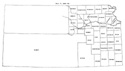
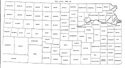
In 1873 the remaining part of the state west of range 25 west was divided into
twenty-two new counties and twelve changes were made in the boundaries of
counties already established. The new counties were Decatur, Rawlins, Cheyenne,
Sheridan, Thomas, Sherman, Lane, Buffalo, Foote, Meade, Scott, Sequoyah,
Arapahoe, Seward, Wichita, Kearney, Grant, Stevens, Greeley, Hamilton, Stanton,
and Kansas (Laws of 1873, pp. 146-156).
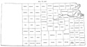
Wabaunsee county took its final form, a tract six miles square being detached
from Riley county and restored to Wabaunsee (id. p. 110).
The line between Riley and Davis, instead of following the Kansas and Republican
rivers, from the west line of township 11, range 8 east, to the east line of
Clay county, was defined by section lines "commencing at the southeast corner of
section 34, township 9, range 4 east; thence east to the southeast corner of
section 34, township 9, range 5 east; thence south to the southeast corner of
section 34, township 11, range 5 east; thence east to the section line in the
middle of township 11, range 6; thence south one mile to the line between the
fourth and fifth tiers of sections of township 11; thence east to the east line
of the county as formerly established" (id. pp. 113-115).
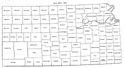
The southern boundary of Barton was pushed six miles south to the line between
townships 21 and 22 (id. p. 112).
The north line of Pawnee was pushed six miles north to the north line of
township 20. Townships 21, 22, and 23, range 15 west, were detached from
Stafford and attached to Pawnee on the east. The south line of Pawnee, beginning
at the northeast corner of township 24, range 15 west, ran eighteen miles west;
thence six miles north; thence eighteen miles west on the north line of township
23 to the east line of Hodgeman county (id. p. 152). The west line of Stafford
was pushed six miles east to the east line of range 15 west (id. p. 153). As
defined by the statute Barton and Stafford overlapped four townships and Barton
and Pawnee one. Kiowa was enlarged by the territory cut off from the south of
Pawnee and by townships 24 and 25, range 15 west, cut off from Stafford.
Barber county was enlarged by township 30, ranges 11, 12, 13, 14, and 15 west,
which were detached from Pratt and by townships 31-35, range 10 west, which were
detached from Harper (id. p. 112).
Townships 21, of ranges 1, 2 and 3 west, were detached from Harvey and given to
McPherson (id. p. 116).
The north line of Clark was pushed six miles north to the north line of township
30, and the west line six miles west to the east line of range 27 west (id. p.
147).
The north line of Ford was pushed six miles north to the north line of township
25, the south line six miles south to the north line of township 30, and the
west line six miles west to the east line of range 27. The south line of
Hodgeman was pushed six miles north to the north line of township 25, and the
west line six miles west to the east line of 27. The west line of Ness was
pushed six miles west to the east line of range 27 east (id. p. 148).
Barber, Cheyenne, Ford, Harper, Ness, Pratt and Reno counties were organized.
The name of Norton county was changed to Billings, but was changed back to
Norton the following year.
Map I, 1855
includes origin of county names
for those counties not existing in 1904. |
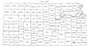
Map II, 1857-'59 |
Map III, 1860 |
Map IV, 1861-1864 |
Map V, 1865-1866 |
Map VI, 1867 |
Map VII, 1868 |
Map VIII, 1869-1872 |
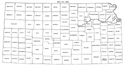
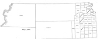
Map IX, 1873 |
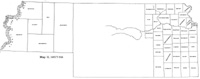
Map X, 1874 |
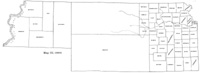
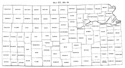
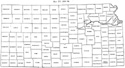
Map XI, 1875-1880 |
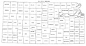
Map XII, 1881, '82 |
Map XIII, 1883,'84 |
Map XIV, 1885 |
Map XV, 1886-1892 |
| |
Map XVI, 1893-1904 |
Article Introduction |
Return to top
Maps and text transcribed from: Transactions of the Kansas State Historical Society, 1903-1904; edited by Geo. W. Martin, Secretary. Vol. VIII. Topeka: Geo. A. Clark, state printer, 1904.
Reproduced with permission of the Kansas State Historical Society.
Background and KSGenWeb logo were designed and are copyrighted by
Tom & Carolyn Ward
for the limited use of the KSGenWeb Project.
Permission is granted for use only on an official KSGenWeb page.
©1999 - Tom & Carolyn Ward
