Maps and text transcribed from: Transactions of the Kansas State Historical Society, 1903-1904; edited by Geo. W. Martin, Secretary. Vol. VIII. Topeka: Geo. A. Clark, state printer, 1904.
Reproduced with permission of the Kansas State Historical Society.
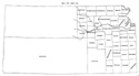
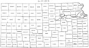
Meade and Clark counties were reestablished. The north line of township 30 was
made the north line of both counties. Clark extended from the east line of range
21 to the east line of range 26 west, and Meade from the east line of range 26
to the east line of range 31. (Laws of 1885, pp. 243-249.)
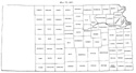
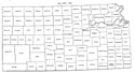
Clark, Comanche, Meade and Thomas counties were organized.
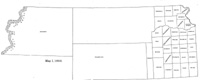
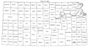
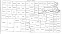
Map I, 1855
includes origin of county names
for those counties not existing in 1904. |
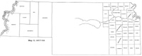
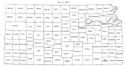
Map II, 1857-'59 |
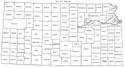
Map III, 1860 |
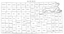
Map IV, 1861-1864 |
Map V, 1865-1866 |
Map VI, 1867 |
Map VII, 1868 |
Map VIII, 1869-1872 |
Map IX, 1873 |
Map X, 1874 |
Map XI, 1875-1880 |
Map XII, 1881, '82 |
Map XIII, 1883,'84 |
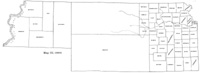
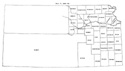
Map XIV, 1885 |
Map XV, 1886-1892 |
| |
Map XVI, 1893-1904 |
Article Introduction |
Return to top
Maps and text transcribed from: Transactions of the Kansas State Historical Society, 1903-1904; edited by Geo. W. Martin, Secretary. Vol. VIII. Topeka: Geo. A. Clark, state printer, 1904.
Reproduced with permission of the Kansas State Historical Society.
Background and KSGenWeb logo were designed and are copyrighted by
Tom & Carolyn Ward
for the limited use of the KSGenWeb Project.
Permission is granted for use only on an official KSGenWeb page.
©1999 - Tom & Carolyn Ward
