Maps and text transcribed from: Transactions of the Kansas State Historical Society, 1903-1904; edited by Geo. W. Martin, Secretary. Vol. VIII. Topeka: Geo. A. Clark, state printer, 1904.
Reproduced with permission of the Kansas State Historical Society.
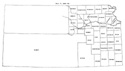
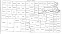
By 1857 the survey had progressed so far that it was possible to bound the
eastern counties by township and sectional lines. An act was passed February 20
correcting the boundaries of all counties established in 1855, except Marion,
Washington and Arapahoe. (Laws of 1857, pp. 37-46.) The west line of Davis,
Wise, Butler and Hunter was pushed four miles east of the line between ranges 4
and 5, east. The strip of land one mile wide and fourteen miles long, between
Atchison and Calhoun counties, was detached from the former and given to the
latter. The west line of Calhoun was placed eleven miles east of the former
line, on the line between the first and second tiers of sections in range 12,
east. The west boundary of Riley was moved eight miles west of the line formerly
established to the line between the second and third tiers of sections in range
4 east, and the eastern boundary was changed to the Big Blue river. Pottawatomie
county was created out of the territory between the Big Blue river and the west
boundary of Calhoun. Washington, Clay and Dickinson counties were created with
the boundaries they now have, except for eight sections which have since been
detached from Morris and given to Dickinson on the east and half a section which
has been included in Dickinson on the west. Pottawatomie, Dickinson, Franklin,
Breckinridge and Jackson counties were organized.
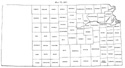
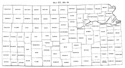
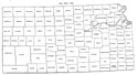
During the year 1859 seven new counties were created and organized: Wyandotte
out of that part of Leavenworth east of the east line of range 22 and that part
of Johnson north of the north line of township 12 (General Laws of 1859, p.
362); Chase out of that part of Wise south of the south line of township 17 and
that part of Butler north of the north line of township 22 (id. p. 361), and
Montana, El Paso, Oro, Broderick, and Fremont, in the extreme western part of
the territory, between the 104th meridian and the mountains. By the act which
created these counties, Arapahoe was limited to the district between the 104th
meridian and the line drawn north from the northeast corner of New Mexico (id.
pp. 357-360).
Two minor changes were made in boundary lines during the year. The line between
Davis and Wise was pushed nine miles north to the line between township 13 and
14 (id. p. 361). The line between Madison and Breckinridge was pushed from the
center to the south line of township 19 (id. p. 357).
In consequence of the strong antislavery feeling which prevailed during the
period of the border war, the names of several counties, given in honor of
prominent proslavery men, were changed. Richardson was changed to Wabaunsee,
Wise to Morris, and Calhoun to Jackson (id. pp. 376, 377, 572, 573).
Osage, Butler, Coffey and Wabaunsee counties were organized.
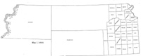
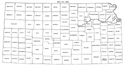
Map I, 1855
includes origin of county names
for those counties not existing in 1904. |
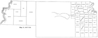
Map II, 1857-'59 |
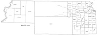
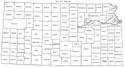
Map III, 1860 |
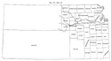
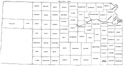
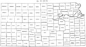
Map IV, 1861-1864 |
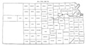
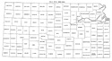
Map V, 1865-1866 |
Map VI, 1867 |
Map VII, 1868 |
Map VIII, 1869-1872 |
Map IX, 1873 |
Map X, 1874 |
Map XI, 1875-1880 |
Map XII, 1881, '82 |
Map XIII, 1883,'84 |
Map XIV, 1885 |
Map XV, 1886-1892 |
| |
Map XVI, 1893-1904 |
Article Introduction |
Return to top
Maps and text transcribed from: Transactions of the Kansas State Historical Society, 1903-1904; edited by Geo. W. Martin, Secretary. Vol. VIII. Topeka: Geo. A. Clark, state printer, 1904.
Reproduced with permission of the Kansas State Historical Society.
Background and KSGenWeb logo were designed and are copyrighted by
Tom & Carolyn Ward
for the limited use of the KSGenWeb Project.
Permission is granted for use only on an official KSGenWeb page.
©1999 - Tom & Carolyn Ward
